
Errol topographic map
Click on the map to display elevation.
About this map
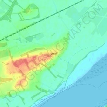
Name: Errol topographic map, elevation, terrain.
Location: Errol, Perth and Kinross, Scotland, PH2 7QW, United Kingdom (56.37131 -3.23525 56.41131 -3.19525)
Average elevation: 13 m
Minimum elevation: -1 m
Maximum elevation: 56 m
Other topographic maps
Click on a map to view its topography, its elevation and its terrain.
Loch Tay
United Kingdom > Scotland > Perth and Kinross > Kenmore
In the Early Medieval period people began to cultivate the higher elevations of the hills around the loch. The Macnabs, the Menzies, the Drummonds, the Napiers, the Haldanes, the MacGregors and the Robertsons of Carwhin and Strowan all owned land around the loch but little remains of their possible…
Average elevation: 460 m
Dupplin Castle
United Kingdom > Scotland > Perth and Kinross > Forteviot > Aberdalgie
Average elevation: 74 m
Glen Shee
United Kingdom > Scotland > Perth and Kinross > Spittal of Glenshee
The A93 road, part of General Wade's military road from Perth to Fort George, runs north through the glen and on into Glen Beag, where it crosses the Cairnwell Pass, which at an elevation of 2,200 feet (670 metres) is the highest public road in the UK. The road climbing to the summit is now wide and straight…
Average elevation: 387 m
Loch Leven National Nature Reserve
United Kingdom > Scotland > Perth and Kinross > Kinross
Average elevation: 119 m
The Birks of Aberfeldy
United Kingdom > Scotland > Perth and Kinross > Aberfeldy
Average elevation: 222 m
Loch Monzievaird
United Kingdom > Scotland > Perth and Kinross > Crieff > Monzievaird
Average elevation: 121 m
Loch Errochty
United Kingdom > Scotland > Perth and Kinross
Loch Errochty is a man made freshwater loch situated within the Perth and Kinross council area at the edge of the Scottish Highlands near the Highland Boundary Fault where the topography changes to lowland.
Average elevation: 457 m