
Make a donation
Gear up for your next adventure:
As an Amazon Associate, this site earns from qualifying purchases at no extra cost to you.
West Siang topographic map
Click on the map to display elevation.
Make a donation
Gear up for your next adventure:
As an Amazon Associate, this site earns from qualifying purchases at no extra cost to you.
About this map
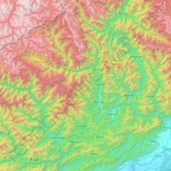
Name: West Siang topographic map, elevation, terrain.
Location: West Siang, Siang District, Arunachal Pradesh, India (27.70000 93.85000 29.10000 95.25000)
Average elevation: 1,812 m
Minimum elevation: 108 m
Maximum elevation: 5,450 m
Make a donation
Gear up for your next adventure:
As an Amazon Associate, this site earns from qualifying purchases at no extra cost to you.
Other topographic maps
Click on a map to view its topography, its elevation and its terrain.
Tawang district
Tawang district occupies an area of 2,172 square kilometres (839 sq mi),. The district is roughly located around latitude 27° 45’ N and longitude 90° 15’ E at the northwest extremity of South Tibet. Elevations range between 6,000 and 22,000 feet (6,700 m), and inhabitants are found at lower altitude,…
Average elevation: 3,767 m
Make a donation
Gear up for your next adventure:
As an Amazon Associate, this site earns from qualifying purchases at no extra cost to you.
Make a donation
Gear up for your next adventure:
As an Amazon Associate, this site earns from qualifying purchases at no extra cost to you.
Make a donation
Gear up for your next adventure:
As an Amazon Associate, this site earns from qualifying purchases at no extra cost to you.
Make a donation
Gear up for your next adventure:
As an Amazon Associate, this site earns from qualifying purchases at no extra cost to you.
Anjaw district
Anjaw District (Pron:/ˈændʒɔ:/) is an administrative district in the state of Arunachal Pradesh in north-east India. It was created district in 2004, by splitting off from the Lohit district under the Arunachal Pradesh Re-organization of Districts Amendment Act. The district borders China on the north.…
Average elevation: 2,846 m
Make a donation
Gear up for your next adventure:
As an Amazon Associate, this site earns from qualifying purchases at no extra cost to you.
Tirap
Tirap district occupies an area of 2,362 square kilometres (912 sq mi), comparatively equivalent to Canada's Cornwall Island. The elevation ranges from 200 meters in the northwest to 4,000 meters in the Patkai Hills. After bifurcation the district occupied an area of 1,170 square km.
Average elevation: 784 m
Make a donation
Gear up for your next adventure:
As an Amazon Associate, this site earns from qualifying purchases at no extra cost to you.
Make a donation
Gear up for your next adventure:
As an Amazon Associate, this site earns from qualifying purchases at no extra cost to you.
Make a donation
Gear up for your next adventure:
As an Amazon Associate, this site earns from qualifying purchases at no extra cost to you.
Make a donation
Gear up for your next adventure:
As an Amazon Associate, this site earns from qualifying purchases at no extra cost to you.