Geolocate

Darak Circle topographic map

Click on the map to display elevation.

About this map

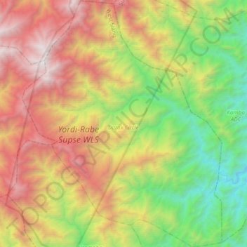
Name: Darak Circle topographic map, elevation, terrain.

Location: Darak Circle, West Siang, Arunachal Pradesh, India (28.14519 94.37426 28.40469 94.61306)

Average elevation: 1,803 m

Minimum elevation: 307 m

Maximum elevation: 3,949 m

Other topographic maps

Click on a map to view its topography, its elevation and its terrain.

Gear up for your next adventure:

🔭Compact Binoculars - Lightweight optics for scouting trails and wildlife
🥾Hiking Gaiters - Protect legs and shoes from mud, snow, and debris
🥫Freeze-Dried Meals - Lightweight, high-calorie nutrition for multi-day treks
🗺️Topographic Maps - Detailed maps to explore trails, mountains, and wilderness areas
🧥Waterproof Pants - Keep dry during rainy hiking conditions

As an Amazon Associate, this site earns from qualifying purchases at no extra cost to you.