
Thank you for supporting this site ❤️
Make a donation
Make a donation
Gear up for your next adventure:
As an Amazon Associate, this site earns from qualifying purchases at no extra cost to you.
Eagle Nest WLS topographic map
Click on the map to display elevation.
Thank you for supporting this site ❤️
Make a donation
Make a donation
Gear up for your next adventure:
As an Amazon Associate, this site earns from qualifying purchases at no extra cost to you.
About this map
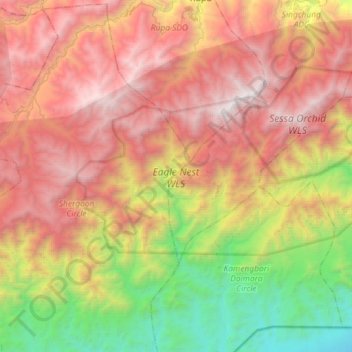
Name: Eagle Nest WLS topographic map, elevation, terrain.
Average elevation: 1,680 m
Minimum elevation: 149 m
Maximum elevation: 3,247 m
Thank you for supporting this site ❤️
Make a donation
Make a donation
Gear up for your next adventure:
As an Amazon Associate, this site earns from qualifying purchases at no extra cost to you.
Other topographic maps
Click on a map to view its topography, its elevation and its terrain.
Sessa Orchid Sanctuary
India > Arunachal Pradesh > Bhalukpong EAC
Sessa sanctuary is drained by the Tippi Naala (Tippi river), which joins the Kameng river at Tippi village on the Bhalukpong-Bomdila highway. Topographic map
Average elevation: 1,414 m