Geolocate

Alto topographic map

Click on the map to display elevation.

About this map

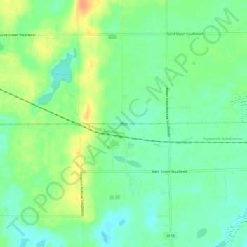
Name: Alto topographic map, elevation, terrain.

Location: Alto, Bowne Township, Kent County, Michigan, United States (42.83650 -85.40044 42.87650 -85.36044)

Average elevation: 252 m

Minimum elevation: 237 m

Maximum elevation: 275 m

Other topographic maps

Click on a map to view its topography, its elevation and its terrain.

Pickerel Lake

United States > Michigan > Kent County

Average elevation: 268 m

Nelson Township

United States > Michigan > Kent County

Average elevation: 275 m

Oakfield Township

United States > Michigan > Kent County

Average elevation: 265 m

Byron Township

United States > Michigan > Kent County

Average elevation: 221 m

Lake Leota

United States > Michigan > Kent County > Walker

Average elevation: 199 m

Sparta Township

United States > Michigan > Kent County

Average elevation: 246 m

Ada Township

United States > Michigan > Kent County

Average elevation: 228 m

Gaines Township

United States > Michigan > Kent County

Average elevation: 243 m

Solon Township

United States > Michigan > Kent County

Average elevation: 263 m

Cordes Lake

United States > Michigan > Kent County

Average elevation: 275 m

Scram Lake

United States > Michigan > Kent County

Average elevation: 270 m

Gear up for your next adventure:

🦌Outdoor Trail Camera - Monitor wildlife activity near your favorite spots
🐕Hiking Dog Pack - Let your canine companion carry their own water and food
🕶️Polarized Sunglasses - Reduces glare from snow and water at high elevations
🔦UV Flashlight - Detect minerals or specific insects in the dark
🥾Durable Hiking Shoes - Long-lasting shoes for frequent hiking

As an Amazon Associate, this site earns from qualifying purchases at no extra cost to you.