Geolocate

Solon Township topographic map

Click on the map to display elevation.

About this map

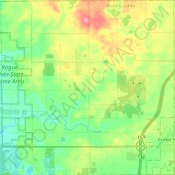
Name: Solon Township topographic map, elevation, terrain.

Location: Solon Township, Kent County, Michigan, United States (43.20502 -85.67294 43.29426 -85.55107)

Average elevation: 263 m

Minimum elevation: 228 m

Maximum elevation: 324 m

Other topographic maps

Click on a map to view its topography, its elevation and its terrain.

Kentwood

United States > Michigan > Kent County > Kentwood

Average elevation: 218 m

Alton

United States > Michigan > Kent County > Vergennes Township

Average elevation: 254 m

Cordes Lake

United States > Michigan > Kent County

Average elevation: 275 m

Scram Lake

United States > Michigan > Kent County

Average elevation: 270 m

Lake Leota

United States > Michigan > Kent County > Walker

Average elevation: 199 m

Alaska

United States > Michigan > Kent County

Average elevation: 230 m

Alto

United States > Michigan > Kent County

Average elevation: 252 m

Ada

United States > Michigan > Kent County

Average elevation: 208 m

Gear up for your next adventure:

🧦Thermal Socks - Warm socks for winter hiking or camping
Lightweight Camping Tent - Portable shelter optimized for Canadian backcountry camping
🥾Mountain Trail Shoes - High-traction shoes for mountain trails
🪑Insulated Seat Pad - Protect your seat from cold rocks and wet logs
🔦UV Flashlight - Detect minerals or specific insects in the dark

As an Amazon Associate, this site earns from qualifying purchases at no extra cost to you.