Geolocate

Morelos topographic map

Click on the map to display elevation.

About this map

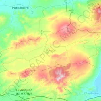
Name: Morelos topographic map, elevation, terrain.

Location: Morelos, Michoacán, Mexico (19.93891 -101.56645 20.04483 -101.32326)

Average elevation: 2,222 m

Minimum elevation: 1,834 m

Maximum elevation: 2,942 m

Other topographic maps

Click on a map to view its topography, its elevation and its terrain.

Zacapu

Mexico > Michoacán > Zacapu

Average elevation: 2,262 m

La Yerbabuena

Mexico > Michoacán > Tlazazalca

Average elevation: 1,911 m

Villa Morelos

Mexico > Michoacán > Morelos > Villa Morelos

Average elevation: 2,352 m

Chaparaco

Mexico > Michoacán > Zamora

Average elevation: 1,624 m

Jesús del Monte

Mexico > Michoacán > Morelia

Average elevation: 2,136 m

Las Cieneguitas

Mexico > Michoacán > Tanhuato

Average elevation: 1,567 m

Ihuatzio

Mexico > Michoacán > Tzintzuntzan

Ihuatzio is located on the southeast of the Lake Pátzcuaro, about 8 kilometers southwest of the town center of Tzintzuntzan. Its average elevation is 2,052 meters above the sea level.

Average elevation: 2,052 m

Zurumbeneo

Mexico > Michoacán > Zurumbeneo

Average elevation: 2,029 m

Gear up for your next adventure:

🐕Hiking Dog Pack - Let your canine companion carry their own water and food
🧥Thermal Layer - Insulating layer for cold outdoor conditions
🛶Kayak Dry Bag - Waterproof storage for kayaking adventures
Family Camping Tent - Spacious tent suitable for family camping trips
🥾Hiking Boots - Sturdy boots providing ankle support and traction on rugged trails

As an Amazon Associate, this site earns from qualifying purchases at no extra cost to you.