Geolocate

Zacapu topographic map

Click on the map to display elevation.

About this map

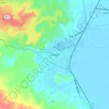
Name: Zacapu topographic map, elevation, terrain.

Location: Zacapu, Michoacán, 58600, Mexico (19.65841 -101.95251 19.97841 -101.63251)

Average elevation: 2,262 m

Minimum elevation: 1,786 m

Maximum elevation: 3,374 m

Gear up for your next adventure:

🛶Kayak Dry Bag - Waterproof storage for kayaking adventures
🧣Merino Neck Gaiter - Protects against wind, sun, and cold at high altitudes
🔥Emergency Fire Starter - Reliable ignition source for all weather conditions
🌬️Windproof Camp Stove - Efficient cooking even on exposed mountain peaks
🛶Canoe Life Vest - Safety vest for water sports

As an Amazon Associate, this site earns from qualifying purchases at no extra cost to you.