Geolocate

Cook Lake topographic map

Click on the map to display elevation.

About this map

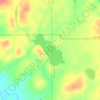
Name: Cook Lake topographic map, elevation, terrain.

Location: Cook Lake, Lake County, Minnesota, United States (47.82430 -91.03259 47.83282 -91.01936)

Average elevation: 534 m

Minimum elevation: 502 m

Maximum elevation: 562 m

Other topographic maps

Click on a map to view its topography, its elevation and its terrain.

Blackstone Lake

United States > Minnesota > Lake County

Average elevation: 438 m

Coffee Creek

United States > Minnesota > Lake County

Average elevation: 521 m

Isabella

United States > Minnesota > Lake County > Isabella

Average elevation: 594 m

Pickerel Lake

United States > Minnesota > Lake County

Average elevation: 435 m

Jack Lake

United States > Minnesota > Lake County

Average elevation: 509 m

Bright Lake

United States > Minnesota > Lake County

Average elevation: 431 m

Bonnie Lake

United States > Minnesota > Lake County

Average elevation: 437 m

Quartz Lake

United States > Minnesota > Lake County

Average elevation: 471 m

Fulton Creek

United States > Minnesota > Lake County

Average elevation: 560 m

Gear up for your next adventure:

Bushcraft Tarp - Versatile emergency shelter or gear protection
🎒Hiking Daypack - Lightweight and durable backpacks for day trips and excursions
🧴First Aid Kit - Essential first aid supplies for outdoor emergencies
🛌Down Sleeping Bag - Superior warmth-to-weight ratio for cold nights
🍽️Titanium Camping Spork - Ultralight and indestructible eating utensil

As an Amazon Associate, this site earns from qualifying purchases at no extra cost to you.