Geolocate

Viking topographic map

Click on the map to display elevation.

About this map

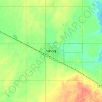
Name: Viking topographic map, elevation, terrain.

Location: Viking, Division No. 10, Alberta, T0B 4N0, Canada (53.05729 -111.81715 53.13729 -111.73715)

Average elevation: 696 m

Minimum elevation: 676 m

Maximum elevation: 724 m

Division No. 10 trails, hiking, mountain biking, running and outdoor activities

Other topographic maps

Click on a map to view its topography, its elevation and its terrain.

Village of Innisfree

Canada > Alberta > Division No. 10

Average elevation: 679 m

Village of Myrnam

Canada > Alberta > Division No. 10

Average elevation: 609 m

Gear up for your next adventure:

🧥Softshell Hiking Jacket - The perfect balance of wind protection and breathability
🧤Insulated Winter Gloves - Heavy-duty protection for sub-zero Canadian adventures
🥾Trail Running Shoes - Lightweight and durable shoes for trail running
💡Solar Camping Lamp - Eco-friendly lighting for campsites
Camping Tent - Weather-resistant tents suitable for 2 to 6 people

As an Amazon Associate, this site earns from qualifying purchases at no extra cost to you.