
Village of Myrnam topographic map
Interactive map
Click on the map to display elevation.
About this map
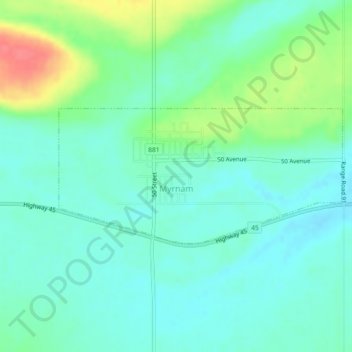
Name: Village of Myrnam topographic map, elevation, terrain.
Location: Village of Myrnam, Division No. 10, Alberta, Canada (53.65476 -111.24313 53.66511 -111.20639)
Average elevation: 609 m
Minimum elevation: 591 m
Maximum elevation: 656 m
Other topographic maps
Click on a map to view its topography, its elevation and its terrain.
Village of Innisfree
Canada > Alberta > Division No. 10
Village of Innisfree, Division No. 10, Alberta, T0B 2G0, Canada
Average elevation: 679 m
Meeting Creek
Canada > Alberta > Division No. 10
Meeting Creek, Division No. 10, Alberta, Canada
Average elevation: 763 m
Bashaw
Canada > Alberta > Division No. 10
Bashaw, Division No. 10, Alberta, T0B 0H0, Canada
Average elevation: 796 m
Town of Vegreville
Canada > Alberta > Division No. 10
Town of Vegreville, Division No. 10, Alberta, Canada
Average elevation: 638 m
Camrose
Canada > Alberta > Division No. 10
Camrose, Division No. 10, Alberta, Canada
Average elevation: 746 m
Vermilion
Canada > Alberta > Division No. 10
Vermilion, Division No. 10, Alberta, T9X 1B7, Canada
Average elevation: 616 m