
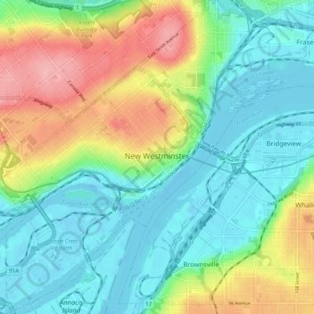
New Westminster topographic map
Interactive map
Click on the map to display elevation.
About this map
Name: New Westminster topographic map, elevation, terrain.
Average elevation: 44 m
Minimum elevation: -8 m
Maximum elevation: 135 m
Routes: Metro Vancouver Regional District GPS tracks, routes, trails, hikes
Other topographic maps
Click on a map to view its topography, its elevation and its terrain.
Vancouver
Canada > British Columbia > Metro Vancouver Regional District
Winters in Greater Vancouver are the fourth-mildest of Canadian cities after nearby Victoria, Nanaimo and Duncan, all on Vancouver Island. Vancouver's growing season averages 237 days, from March 18 until November 10. Vancouver's 1981–2010 USDA Plant Hardiness Zone ranges from 8A to 9A depending on elevation…
Average elevation: 34 m
Burnaby
Canada > British Columbia > Metro Vancouver Regional District
Burnaby occupies 98.6 square kilometres (38.1 sq mi) and is located at the geographic centre of the Metro Vancouver Regional District. The regional district's government is located in Burnaby's Metrotown area. Situated between the city of Vancouver on the west and Port Moody, Coquitlam, and New Westminster on…
Average elevation: 59 m
Township of Langley
Canada > British Columbia > Metro Vancouver Regional District
Average elevation: 47 m
Coquitlam
Canada > British Columbia > Metro Vancouver Regional District
Like much of Metro Vancouver, Coquitlam has an oceanic climate (Köppen climate type Cfb), experiencing mild temperatures and high precipitation; warm, dry summers and cool, wet winters. However, compared to most other cities in the area, precipitation is especially heavy in Coquitlam due to its proximity to…
Average elevation: 190 m
Aldergrove
Canada > British Columbia > Metro Vancouver Regional District > Township of Langley
Average elevation: 107 m
University Endowment Lands
Canada > British Columbia > Metro Vancouver Regional District
Snowfalls are also more common than many parts of the City of Vancouver because of the area's higher altitude and the lack of an urban heat island due to less terrestrial development.
Average elevation: 58 m
Burnaby
Canada > British Columbia > Metro Vancouver Regional District > Burnaby
Burnaby occupies 98.60 square kilometres (38.07 sq mi) and is located at the geographic centre of the Metro Vancouver area and home to the Metro Vancouver regional government in Metrotown. Situated between the city of Vancouver on the west and Port Moody, Coquitlam, and New Westminster on the east, Burnaby is…
Average elevation: 144 m
Cloverdale
Canada > British Columbia > Metro Vancouver Regional District > Surrey
Average elevation: 24 m
Surrey--Newton
Canada > British Columbia > Metro Vancouver Regional District > Surrey
Average elevation: 71 m
District of North Vancouver
Canada > British Columbia > Metro Vancouver Regional District
Average elevation: 358 m
Tsawwassen
Canada > British Columbia > Metro Vancouver Regional District > Delta
Average elevation: 12 m
Stanley Park
Canada > British Columbia > Metro Vancouver Regional District > Vancouver
Average elevation: 14 m
Coquitlam
Canada > British Columbia > Metro Vancouver Regional District > Coquitlam
Southwest Coquitlam comprises the original core of the city, with Maillardville and Fraser River industrial sector giving way to the large residential areas of Austin Heights, colloquially referred to as "The Bump" due to its high and flat plateau topography. These older residences, with larger property…
Average elevation: 230 m
Langley Township
Canada > British Columbia > Metro Vancouver Regional District > Township of Langley > Langley Township
Average elevation: 37 m
Yew Lake
Canada > British Columbia > Metro Vancouver Regional District > West Vancouver
Average elevation: 990 m
Jericho Beach
Canada > British Columbia > Metro Vancouver Regional District > Vancouver
Average elevation: 20 m
Bowen Island
Canada > British Columbia > Metro Vancouver Regional District > Bowen Island Municipality
Average elevation: 106 m
Tsawwassen Causeway Beach
Canada > British Columbia > Metro Vancouver Regional District > Delta
Average elevation: 1 m
Surrey Lake
Canada > British Columbia > Metro Vancouver Regional District > Surrey
Average elevation: 26 m
Grouse Mountain
Canada > British Columbia > Metro Vancouver Regional District
Grouse Mountain is one of the North Shore Mountains of the Pacific Ranges in the District Municipality of North Vancouver, British Columbia, Canada. With a maximum elevation of over 1,200 m (4,100 feet) at its peak, the mountain is the site of an alpine ski area, Grouse Mountain Resort, which overlooks Greater…
Average elevation: 968 m
Dunbar-Southlands
Canada > British Columbia > Metro Vancouver Regional District > Vancouver
Average elevation: 43 m
Burnaby Mountain
Canada > British Columbia > Metro Vancouver Regional District > Burnaby
Due to its relatively high elevation, snow will often fall on the higher levels of Burnaby Mountain while rain falls in the surrounding cities. Tobogganing is a popular pastime at Centennial Park on winter days with snow.
Average elevation: 167 m
Newton Athletic Park
Canada > British Columbia > Metro Vancouver Regional District > Surrey
Average elevation: 86 m
Livingstone Lake
Canada > British Columbia > Metro Vancouver Regional District > Vancouver
Average elevation: 86 m
Maywood
Canada > British Columbia > Metro Vancouver Regional District > Burnaby
Average elevation: 113 m
Ocean Rocks Viewpoint
Canada > British Columbia > Metro Vancouver Regional District > Bowen Island Municipality
Average elevation: 33 m
Kerrisdale
Canada > British Columbia > Metro Vancouver Regional District > Vancouver
Average elevation: 39 m
Kitsilano
Canada > British Columbia > Metro Vancouver Regional District > Vancouver
Average elevation: 24 m
English Bay
Canada > British Columbia > Metro Vancouver Regional District > Vancouver
Average elevation: 7 m
Buntzen Bay
Canada > British Columbia > Metro Vancouver Regional District > Anmore
Average elevation: 214 m
Victoria-Fraserview
Canada > British Columbia > Metro Vancouver Regional District > Vancouver
Average elevation: 67 m
Pitt Lake
Canada > British Columbia > Metro Vancouver Regional District > Electoral Area A
Average elevation: 659 m
Queen Elizabeth Park
Canada > British Columbia > Metro Vancouver Regional District > Vancouver
Average elevation: 81 m
Golden Ears Provincial Park
Canada > British Columbia > Metro Vancouver Regional District
Average elevation: 794 m
Crescent Beach
Canada > British Columbia > Metro Vancouver Regional District > Surrey
Average elevation: 22 m
Finn Slough
Canada > British Columbia > Metro Vancouver Regional District > Richmond
Average elevation: 2 m