
Make a donation
Gear up for your next adventure:
As an Amazon Associate, this site earns from qualifying purchases at no extra cost to you.
Bowen Island topographic map
Click on the map to display elevation.
Make a donation
Gear up for your next adventure:
As an Amazon Associate, this site earns from qualifying purchases at no extra cost to you.
About this map
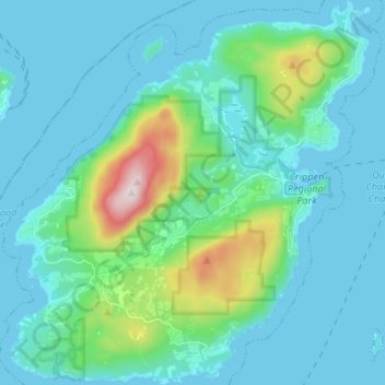
Name: Bowen Island topographic map, elevation, terrain.
Average elevation: 106 m
Minimum elevation: -1 m
Maximum elevation: 718 m
Metro Vancouver Regional District trails, hiking, mountain biking, running and outdoor activities
Make a donation
Gear up for your next adventure:
As an Amazon Associate, this site earns from qualifying purchases at no extra cost to you.
Other topographic maps
Click on a map to view its topography, its elevation and its terrain.
North Peak
Canada > British Columbia > Metro Vancouver Regional District > Bowen Island Municipality
Average elevation: 331 m
Ocean Rocks Viewpoint
Canada > British Columbia > Metro Vancouver Regional District > Bowen Island Municipality
Average elevation: 33 m