Geolocate

Troyan topographic map

Click on the map to display elevation.

About this map

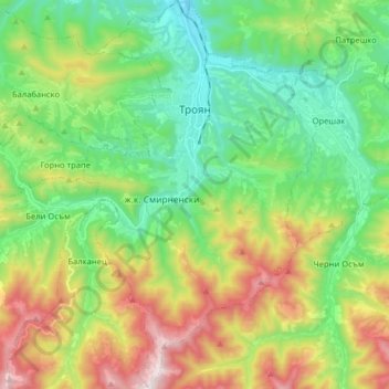
Name: Troyan topographic map, elevation, terrain.

Location: Troyan, Lovech, Bulgaria (42.80637 24.66651 42.92376 24.76265)

Average elevation: 640 m

Minimum elevation: 350 m

Maximum elevation: 1,196 m

Other topographic maps

Click on a map to view its topography, its elevation and its terrain.

Karlukovo

Bulgaria > Lovech

Average elevation: 269 m

Kakrina

Bulgaria > Lovech

Average elevation: 457 m

Teteven

Bulgaria > Lovech

Teteven is located in a mountainous area, in the foothills of the Balkan mountains between the peaks Ostrich, Petrahilya, Cherven, Treskavets and Vezhen. The river Vit meanders through the town. The altitude of Teteven district varies from 340 to 2100 m, and in the town center it is 415 m. The climate is…

Average elevation: 765 m

Toros

Bulgaria > Lovech

Average elevation: 246 m

Cherni Vit

Bulgaria > Lovech

Average elevation: 643 m

Lukovit

Bulgaria > Lovech

Average elevation: 197 m

Картала

Bulgaria > Lovech

Average elevation: 1,783 m

Gear up for your next adventure:

🛶Kayak Dry Bag - Waterproof storage for kayaking adventures
🪑Insulated Seat Pad - Protect your seat from cold rocks and wet logs
💡Solar Camping Lamp - Eco-friendly lighting for campsites
🔦LED Flashlight - Powerful and long-lasting flashlight for camping and emergencies
🧰Emergency Multi-Tool - Compact multi-tool for outdoor survival

As an Amazon Associate, this site earns from qualifying purchases at no extra cost to you.