
Teteven topographic map
Click on the map to display elevation.
Teteven
Teteven is located in a mountainous area, in the foothills of the Balkan mountains between the peaks Ostrich, Petrahilya, Cherven, Treskavets and Vezhen. The river Vit meanders through the town. The altitude of Teteven district varies from 340 to 2100 m, and in the town center it is 415 m. The climate is temperate continental with cold winters and cool summers. The territory of Teteven is about 697 km2, which is 16.86% of the territory of Lovech district.
About this map
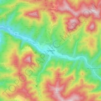
Name: Teteven topographic map, elevation, terrain.
Location: Teteven, Lovech, Bulgaria (42.87783 24.22511 42.95783 24.30511)
Average elevation: 765 m
Minimum elevation: 366 m
Maximum elevation: 1,224 m
Other topographic maps
Click on a map to view its topography, its elevation and its terrain.