Geolocate

Toros topographic map

Click on the map to display elevation.

About this map

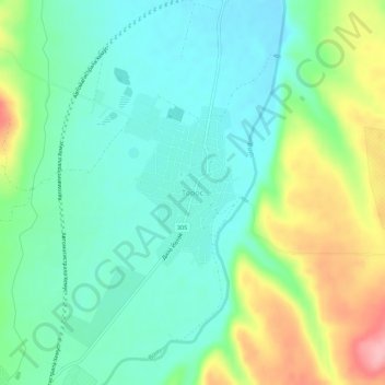
Name: Toros topographic map, elevation, terrain.

Location: Toros, Lukovit, Lovech, Bulgaria (43.07671 24.25827 43.11671 24.29827)

Average elevation: 246 m

Minimum elevation: 203 m

Maximum elevation: 342 m

Other topographic maps

Click on a map to view its topography, its elevation and its terrain.

Central Balkan National Park

Bulgaria > Lovech

Average elevation: 646 m

Beli Osam

Bulgaria > Lovech

Average elevation: 892 m

Oreshak

Bulgaria > Lovech

Average elevation: 556 m

Troyan

Bulgaria > Lovech

Average elevation: 640 m

Gear up for your next adventure:

🧥Thermal Fleece Jacket - Versatile insulation for changing mountain temperatures
🧢Sun Protection Cap - Breathable cap to protect from sun exposure
🥾Waterproof Hiking Boots - Boots keeping your feet dry in wet conditions
🗺️Topographic Maps - Detailed maps to explore trails, mountains, and wilderness areas
Backpacking Tent - Lightweight tent for long-distance hiking trips

As an Amazon Associate, this site earns from qualifying purchases at no extra cost to you.