Geolocate

Salome topographic map

Click on the map to display elevation.

About this map

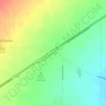
Name: Salome topographic map, elevation, terrain.

Location: Salome, La Paz County, Arizona, United States (33.76114 -113.63465 33.80114 -113.59465)

Average elevation: 573 m

Minimum elevation: 549 m

Maximum elevation: 605 m

Other topographic maps

Click on a map to view its topography, its elevation and its terrain.

Salome

United States > Arizona > La Paz County > Wenden

Average elevation: 586 m

Quartzsite

United States > Arizona > La Paz County

Average elevation: 288 m

Alamo Lake

United States > Arizona > La Paz County

Average elevation: 468 m

Parker Strip

United States > Arizona > La Paz County

Average elevation: 259 m

Parker

United States > Arizona > La Paz County

Average elevation: 160 m

Quartzsite

United States > Arizona > La Paz County

Average elevation: 288 m

Gear up for your next adventure:

👟Trail Running Shoes - Agile footwear for fast-paced topographic exploration
🦶Anti-Blister Balm - Prevents friction and hotspots during long ascents
🛌Down Sleeping Bag - Superior warmth-to-weight ratio for cold nights
🥾Trekking Boots - Durable boots for long-distance trekking
🚲Heavy Duty Bike Lock - Secure your bike at the trailhead or during stops

As an Amazon Associate, this site earns from qualifying purchases at no extra cost to you.