Geolocate

Parker Strip topographic map

Click on the map to display elevation.

About this map

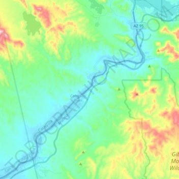
Name: Parker Strip topographic map, elevation, terrain.

Location: Parker Strip, La Paz County, Arizona, United States (34.17256 -114.22864 34.30430 -114.07923)

Average elevation: 259 m

Minimum elevation: 111 m

Maximum elevation: 726 m

Other topographic maps

Click on a map to view its topography, its elevation and its terrain.

Four Peaks

United States > Arizona > La Paz County

Average elevation: 407 m

Salome

United States > Arizona > La Paz County

Average elevation: 573 m

Quartzsite

United States > Arizona > La Paz County

Average elevation: 288 m

Four Peaks

United States > Arizona > La Paz County

Average elevation: 407 m

Gear up for your next adventure:

🧤Thermal Hiking Gloves - Grip-enhanced gloves for cold-weather altitude trekking
👖Convertible Hiking Pants - Zip-off legs to adapt to changing weather conditions
🦶Anti-Blister Balm - Prevents friction and hotspots during long ascents
🧥Insulated Jacket - Keep warm in cold outdoor conditions
🧴First Aid Kit - Essential first aid supplies for outdoor emergencies

As an Amazon Associate, this site earns from qualifying purchases at no extra cost to you.