Geolocate

Parker topographic map

Click on the map to display elevation.

About this map

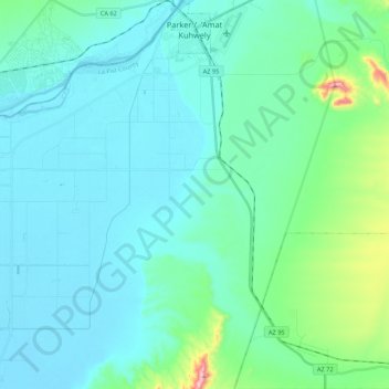
Name: Parker topographic map, elevation, terrain.

Location: Parker, La Paz County, Arizona, 85344, United States (33.98574 -114.30221 34.16330 -114.18035)

Average elevation: 160 m

Minimum elevation: 100 m

Maximum elevation: 530 m

Other topographic maps

Click on a map to view its topography, its elevation and its terrain.

Four Peaks

United States > Arizona > La Paz County

Average elevation: 407 m

Salome

United States > Arizona > La Paz County

Average elevation: 573 m

Quartzsite

United States > Arizona > La Paz County

Average elevation: 288 m

Four Peaks

United States > Arizona > La Paz County

Average elevation: 407 m

Gear up for your next adventure:

🧰Survival Kit - Essential gear for emergencies in the wilderness
🚲Heavy Duty Bike Lock - Secure your bike at the trailhead or during stops
🩹Compact First Aid Kit - Pre-packed essentials for common trail injuries
🛁Quick-Dry Microfiber Towel - Space-saving towel that dries rapidly on the move
🐕Hiking Dog Pack - Let your canine companion carry their own water and food

As an Amazon Associate, this site earns from qualifying purchases at no extra cost to you.