Geolocate

Quartzsite topographic map

Click on the map to display elevation.

About this map

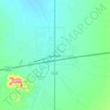
Name: Quartzsite topographic map, elevation, terrain.

Location: Quartzsite, La Paz County, Arizona, United States (33.62395 -114.26982 33.71126 -114.16492)

Average elevation: 288 m

Minimum elevation: 239 m

Maximum elevation: 505 m

Other topographic maps

Click on a map to view its topography, its elevation and its terrain.

Salome

United States > Arizona > La Paz County > Wenden

Average elevation: 586 m

Four Peaks

United States > Arizona > La Paz County

Average elevation: 407 m

Quartzsite

United States > Arizona > La Paz County

Average elevation: 288 m

Alamo Lake

United States > Arizona > La Paz County

Average elevation: 468 m

Salome

United States > Arizona > La Paz County

Average elevation: 573 m

Parker

United States > Arizona > La Paz County

Average elevation: 160 m

Four Peaks

United States > Arizona > La Paz County

Average elevation: 407 m

Parker Strip

United States > Arizona > La Paz County

Average elevation: 259 m

Gear up for your next adventure:

🥾Mountaineering Boots - Supportive boots for climbing and high-altitude hiking
🥾Waterproof Trail Shoes - Shoes designed to handle wet terrain
🗺️Topographic Maps - Detailed maps to explore trails, mountains, and wilderness areas
🧴Sunscreen SPF - Broad-spectrum sunscreen for outdoor activities
🧳Compression Sacks - Maximize space in your backpack by shrinking gear

As an Amazon Associate, this site earns from qualifying purchases at no extra cost to you.