Geolocate

Watermelon Valley topographic map

Click on the map to display elevation.

About this map

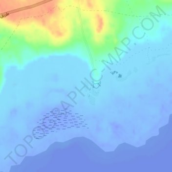
Name: Watermelon Valley topographic map, elevation, terrain.

Location: Watermelon Valley, Faiyum, Egypt (29.50987 30.60064 29.51157 30.60145)

Average elevation: -15 m

Minimum elevation: -49 m

Maximum elevation: 43 m

Other topographic maps

Click on a map to view its topography, its elevation and its terrain.

Wadi al Rayan

Egypt > Faiyum

Average elevation: -8 m

Faiyum

Egypt > Faiyum

Average elevation: 13 m

أبشواى

Egypt > Faiyum

Average elevation: 4 m

Hauwaret al Maqta

Egypt > Faiyum

Average elevation: 26 m

Faiyum

Egypt > Faiyum

Average elevation: 13 m

Tunis

Egypt > Faiyum

Average elevation: -21 m

Ilwat Jibal al Masakhit

Egypt > Faiyum

Average elevation: 51 m

Faiyum Oasis

Egypt > Faiyum

Average elevation: 32 m

Sinnuris

Egypt > Faiyum

Average elevation: 1 m

Tamiya

Egypt > Faiyum

Average elevation: -8 m

Al-Wayet Shakshuk

Egypt > Faiyum

Average elevation: -43 m

Qarun

Egypt > Faiyum

Average elevation: -2 m

Ezbet Hanna Harib

Egypt > Faiyum

Average elevation: 9 m

Khala Muhammad

Egypt > Faiyum

Average elevation: -36 m

Hatem Et Taei

Egypt > Faiyum > Youssef Al Sediq City

Average elevation: 35 m

Tunis Tourist village

Egypt > Faiyum

Average elevation: -21 m

Faiyum

Egypt > Faiyum

Average elevation: 13 m

Itsa

Egypt > Faiyum

Average elevation: 16 m

Lake Qaroun

Egypt > Faiyum

Average elevation: 33 m

Gear up for your next adventure:

🛌Insulated Sleeping Pad - Critical thermal barrier between you and the cold ground
🍽️Titanium Camping Spork - Ultralight and indestructible eating utensil
🔭Outdoor Binoculars - Lightweight binoculars for birdwatching and hiking
🎒Backpack Rain Cover - External shield to keep your entire pack dry
🥾Waterproof Hiking Boots - Boots keeping your feet dry in wet conditions

As an Amazon Associate, this site earns from qualifying purchases at no extra cost to you.