Geolocate

Itsa topographic map

Click on the map to display elevation.

About this map

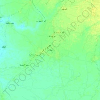
Name: Itsa topographic map, elevation, terrain.

Location: Itsa, Faiyum, 63759, Egypt (29.20051 30.76020 29.28051 30.84020)

Average elevation: 16 m

Minimum elevation: 9 m

Maximum elevation: 25 m

Other topographic maps

Click on a map to view its topography, its elevation and its terrain.

Al Zohor District Village

Egypt > Faiyum

Average elevation: 36 m

First Al Nagarin

Egypt > Faiyum

Average elevation: 23 m

First Al Nagarin

Egypt > Faiyum

Average elevation: 23 m

Wadi Al Rayyan National Park

Egypt > Faiyum

Average elevation: 47 m

Faiyum Oasis

Egypt > Faiyum

Average elevation: 32 m

Watermelon Valley

Egypt > Faiyum

Average elevation: -15 m

Youssef Al Sediq City

Egypt > Faiyum

Average elevation: 7 m

الكعابي الجديدة

Egypt > Faiyum

Average elevation: 19 m

New Al Fayoum City

Egypt > Faiyum

Average elevation: 59 m

Lake Qaroun

Egypt > Faiyum

Average elevation: 33 m

Youssef Al Sediq City

Egypt > Faiyum

Average elevation: 7 m

Gear up for your next adventure:

🥘Camping Cookware Set - Compact nesting pots and pans for trail cooking
🛶Canoe Life Vest - Safety vest for water sports
🥾Hiking Boots - Sturdy boots providing ankle support and traction on rugged trails
🥾Waterproof Hiking Boots - Boots keeping your feet dry in wet conditions
🦶Hiking Shoe Insoles - Added support for high arches and long days on feet

As an Amazon Associate, this site earns from qualifying purchases at no extra cost to you.