
Curve Lake topographic map
Click on the map to display elevation.
About this map
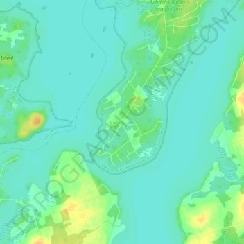
Name: Curve Lake topographic map, elevation, terrain.
Average elevation: 249 m
Minimum elevation: 240 m
Maximum elevation: 269 m
Peterborough County trails, hiking, mountain biking, running and outdoor activities
Other topographic maps
Click on a map to view its topography, its elevation and its terrain.
Kawartha Highlands Provincial Park
Canada > Ontario > Peterborough County > North Kawartha
Average elevation: 306 m
Trent Lakes
Canada > Ontario > Peterborough County
The lumber and agricultural industries are significant to the history of the township. Due to the topography of the region, agricultural production was limited to only certain areas where soil conditions were adequate and cattle and mixed farming (orchards, cattle, horses, sheep, grains, vegetables, chickens…
Average elevation: 293 m
Curve Lake First Nation
Canada > Ontario > Peterborough County > Selwyn > Young's Point
Average elevation: 247 m
Trent-Severn Waterway
Canada > Ontario > Peterborough County > North Kawartha > Burleigh Falls
Average elevation: 249 m
Cordova Lake
Canada > Ontario > Peterborough County > Havelock-Belmont-Methuen
Average elevation: 224 m
Stony Lake
Canada > Ontario > Peterborough County > North Kawartha > Burleigh Falls
Average elevation: 255 m
Methuen Lake
Canada > Ontario > Peterborough County > Havelock-Belmont-Methuen
Average elevation: 293 m