
Selwyn topographic map
Click on the map to display elevation.
About this map
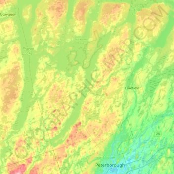
Name: Selwyn topographic map, elevation, terrain.
Average elevation: 253 m
Minimum elevation: 188 m
Maximum elevation: 361 m
Peterborough County trails, hiking, mountain biking, running and outdoor activities
Other topographic maps
Click on a map to view its topography, its elevation and its terrain.
Millbrook
Canada > Ontario > Peterborough County > Cavan-Monaghan
Peterborough's topography is largely defined by land formations created by the receding Wisconsian glaciers 10,000–15,000 years ago. The South End and Downtown portions of the city sit on what was the bottom of the glacial Lake Peterborough—part of a glacial spillway created when glacial meltwaters from…
Average elevation: 250 m
Mount Pleasant
Canada > Ontario > Peterborough County > Cavan-Monaghan > Mount Pleasant
Average elevation: 280 m
Cordova Mines
Canada > Ontario > Peterborough County > Havelock-Belmont-Methuen
Average elevation: 209 m
Trent-Severn Waterway
Canada > Ontario > Peterborough County > North Kawartha > Burleigh Falls
Average elevation: 249 m
Villiers
Canada > Ontario > Peterborough County > Otonabee–South Monaghan > Villiers
Average elevation: 225 m
Millbrook
Canada > Ontario > Peterborough County > Cavan-Monaghan
Peterborough's topography is largely defined by land formations created by the receding Wisconsian glaciers 10,000–15,000 years ago. The South End and Downtown portions of the city sit on what was the bottom of the glacial Lake Peterborough—part of a glacial spillway created when glacial meltwaters from…
Average elevation: 250 m