Geolocate

Cold Lake topographic map

Click on the map to display elevation.

About this map

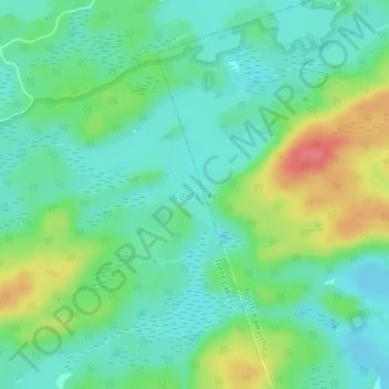
Name: Cold Lake topographic map, elevation, terrain.

Location: Cold Lake, North Kawartha, Peterborough County, Central Ontario, Ontario, Canada (44.68971 -78.28617 44.70997 -78.26524)

Average elevation: 309 m

Minimum elevation: 287 m

Maximum elevation: 355 m

Peterborough County trails, hiking, mountain biking, running and outdoor activities

Other topographic maps

Click on a map to view its topography, its elevation and its terrain.

Haultain

Canada > Ontario > Peterborough County > North Kawartha

Average elevation: 270 m

Eels Lake

Canada > Ontario > Peterborough County > North Kawartha

Average elevation: 361 m

Coon Lake

Canada > Ontario > Peterborough County > North Kawartha

Average elevation: 263 m

Gear up for your next adventure:

🥾Trekking Boots - Durable boots for long-distance trekking
🥾Hiking Boots - Sturdy boots providing ankle support and traction on rugged trails
🧢Beanie Hat - Keep your head warm in cold weather
🧣Merino Neck Gaiter - Protects against wind, sun, and cold at high altitudes
🧥Packable Rain Jacket - Breathable waterproof layer for unpredictable weather

As an Amazon Associate, this site earns from qualifying purchases at no extra cost to you.