
Make a donation
Gear up for your next adventure:
As an Amazon Associate, this site earns from qualifying purchases at no extra cost to you.
Bradwell topographic map
Click on the map to display elevation.
Make a donation
Gear up for your next adventure:
As an Amazon Associate, this site earns from qualifying purchases at no extra cost to you.
About this map
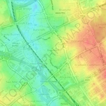
Name: Bradwell topographic map, elevation, terrain.
Location: Bradwell, City of Milton Keynes, England, United Kingdom (52.03824 -0.80461 52.05766 -0.76364)
Average elevation: 88 m
Minimum elevation: 64 m
Maximum elevation: 114 m
Make a donation
Gear up for your next adventure:
As an Amazon Associate, this site earns from qualifying purchases at no extra cost to you.
Other topographic maps
Click on a map to view its topography, its elevation and its terrain.
Willen Lake
United Kingdom > England > City of Milton Keynes > Milton Keynes > Monkston
Average elevation: 67 m
Walton Lake
United Kingdom > England > City of Milton Keynes > Milton Keynes > Monkston
Average elevation: 73 m
Make a donation
Gear up for your next adventure:
As an Amazon Associate, this site earns from qualifying purchases at no extra cost to you.
Milton Keynes
United Kingdom > England > City of Milton Keynes > Milton Keynes
Average elevation: 90 m
Fenny Stratford
United Kingdom > England > City of Milton Keynes > Milton Keynes
Average elevation: 95 m