
Wolverton topographic map
Click on the map to display elevation.
About this map
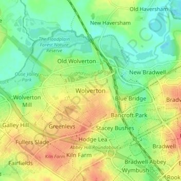
Name: Wolverton topographic map, elevation, terrain.
Average elevation: 82 m
Minimum elevation: 52 m
Maximum elevation: 119 m
Other topographic maps
Click on a map to view its topography, its elevation and its terrain.
Caldecotte Lake
United Kingdom > England > City of Milton Keynes > Milton Keynes > Fenny Stratford
Average elevation: 75 m
Willen Lake
United Kingdom > England > City of Milton Keynes > Milton Keynes > Monkston
Average elevation: 67 m
Milton Keynes
United Kingdom > England > City of Milton Keynes > Milton Keynes
Average elevation: 90 m
Furzton Lake
United Kingdom > England > City of Milton Keynes > Milton Keynes > Bletchley
Average elevation: 93 m
Shenley Church End
United Kingdom > England > City of Milton Keynes > Milton Keynes
Average elevation: 98 m
Walton Lake
United Kingdom > England > City of Milton Keynes > Milton Keynes > Monkston
Average elevation: 73 m
Whitehouse Park
United Kingdom > England > City of Milton Keynes > Milton Keynes > Wolverton
Average elevation: 99 m