
Make a donation
Gear up for your next adventure:
As an Amazon Associate, this site earns from qualifying purchases at no extra cost to you.
Lower Weald topographic map
Click on the map to display elevation.
Make a donation
Gear up for your next adventure:
As an Amazon Associate, this site earns from qualifying purchases at no extra cost to you.
About this map
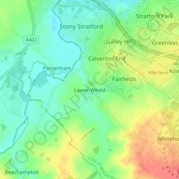
Name: Lower Weald topographic map, elevation, terrain.
Average elevation: 82 m
Minimum elevation: 61 m
Maximum elevation: 118 m
Make a donation
Gear up for your next adventure:
As an Amazon Associate, this site earns from qualifying purchases at no extra cost to you.
Other topographic maps
Click on a map to view its topography, its elevation and its terrain.
Caldecotte Lake
United Kingdom > England > City of Milton Keynes > Milton Keynes > Fenny Stratford
Average elevation: 75 m
Stanton Low Lake
United Kingdom > England > City of Milton Keynes > Wolverton > Old Haversham
Average elevation: 72 m
Make a donation
Gear up for your next adventure:
As an Amazon Associate, this site earns from qualifying purchases at no extra cost to you.
Willen Lake
United Kingdom > England > City of Milton Keynes > Milton Keynes > Monkston
Average elevation: 67 m
Make a donation
Gear up for your next adventure:
As an Amazon Associate, this site earns from qualifying purchases at no extra cost to you.
Furzton Lake
United Kingdom > England > City of Milton Keynes > Milton Keynes > Bletchley
Average elevation: 93 m
Make a donation
Gear up for your next adventure:
As an Amazon Associate, this site earns from qualifying purchases at no extra cost to you.
Shenley Church End
United Kingdom > England > City of Milton Keynes > Milton Keynes
Average elevation: 98 m
Walton Lake
United Kingdom > England > City of Milton Keynes > Milton Keynes > Monkston
Average elevation: 73 m
Make a donation
Gear up for your next adventure:
As an Amazon Associate, this site earns from qualifying purchases at no extra cost to you.
Make a donation
Gear up for your next adventure:
As an Amazon Associate, this site earns from qualifying purchases at no extra cost to you.
Clifton Reynes
United Kingdom > England > City of Milton Keynes > Clifton Reynes
Average elevation: 68 m
Cold Brayfield
United Kingdom > England > City of Milton Keynes > Newton Blossomville
Average elevation: 59 m
Make a donation
Gear up for your next adventure:
As an Amazon Associate, this site earns from qualifying purchases at no extra cost to you.
Make a donation
Gear up for your next adventure:
As an Amazon Associate, this site earns from qualifying purchases at no extra cost to you.
Milton Keynes
United Kingdom > England > City of Milton Keynes > Milton Keynes
Average elevation: 90 m
Make a donation
Gear up for your next adventure:
As an Amazon Associate, this site earns from qualifying purchases at no extra cost to you.
Make a donation
Gear up for your next adventure:
As an Amazon Associate, this site earns from qualifying purchases at no extra cost to you.