Geolocate

Vilavila topographic map

Click on the map to display elevation.

About this map

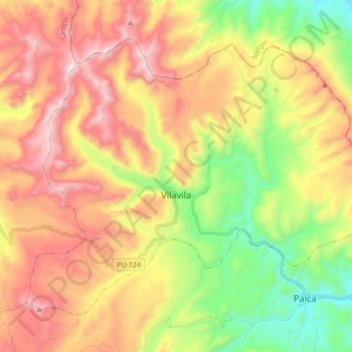
Name: Vilavila topographic map, elevation, terrain.

Location: Vilavila, Province of Lampa, Puno, Peru (-15.24398 -70.73239 -15.11521 -70.56251)

Average elevation: 4,571 m

Minimum elevation: 4,006 m

Maximum elevation: 5,179 m

Other topographic maps

Click on a map to view its topography, its elevation and its terrain.

Allin Qhapaq

Peru > Puno > Macusani

Average elevation: 5,325 m

Luquina Chico

Peru > Puno

Average elevation: 3,865 m

Chillihua

Peru > Puno > Nuñoa

Average elevation: 4,610 m

Arica

Peru > Puno > San Gabán

Average elevation: 1,032 m

Macusani

Peru > Puno > Macusani

Average elevation: 4,508 m

Cunurana

Peru > Puno > Santa Rosa

Average elevation: 4,912 m

Ananta

Peru > Puno > Ituata > Ananta

Average elevation: 4,645 m

Juliaca

Peru > Puno > Juliaca

Average elevation: 3,861 m

San Fracisco

Peru > Puno > Putina

Average elevation: 3,902 m

Saman

Peru > Puno > Samán

Average elevation: 3,824 m

Gear up for your next adventure:

🛏️Camping Sleeping Mat - Comfortable mats for sleeping outdoors
🎒Hiking Backpack - Lightweight and ergonomic backpacks for day hikes or multi-day treks
🔋Solar Power Bank - Keep your GPS and devices charged during long outdoor trips
💡Compact LED Flashlight - Powerful and portable flashlight for outdoor use
🥾Trail Hiking Shoes - Durable shoes designed for rugged trails

As an Amazon Associate, this site earns from qualifying purchases at no extra cost to you.