
Hamar topographic map
Interactive map
Click on the map to display elevation.
About this map
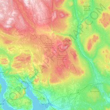
Name: Hamar topographic map, elevation, terrain.
Location: Hamar, Innlandet, Norvège (60.76898 10.98098 61.23604 11.27969)
Average elevation: 445 m
Minimum elevation: 120 m
Maximum elevation: 1,024 m
Other topographic maps
Click on a map to view its topography, its elevation and its terrain.
Viewpoint Snøhetta
Viewpoint Snøhetta, Vålåsjøhøvegen, Dovre, Innlandet, 2661, Norvège
Average elevation: 1,157 m