
Lillehammer topographic map
Interactive map
Click on the map to display elevation.
About this map
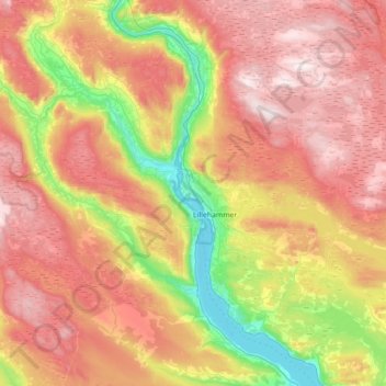
Name: Lillehammer topographic map, elevation, terrain.
Location: Lillehammer, Innlandet, Norvège (61.01855 10.03773 61.24803 10.74367)
Average elevation: 593 m
Minimum elevation: 119 m
Maximum elevation: 1,089 m
Other topographic maps
Click on a map to view its topography, its elevation and its terrain.
Viewpoint Snøhetta
Viewpoint Snøhetta, Vålåsjøhøvegen, Dovre, Innlandet, 2661, Norvège
Average elevation: 1,157 m