

Telangana topographic map
Click on the map to display elevation.
About this map
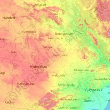
Name: Telangana topographic map, elevation, terrain.
Location: Telangana, India (15.83642 77.23659 19.91730 81.32262)
Average elevation: 320 m
Minimum elevation: 0 m
Maximum elevation: 1,262 m
Other topographic maps
Click on a map to view its topography, its elevation and its terrain.
Kargil
India > Ladakh > Kargil tehsil
Kargil has an average elevation of 2,676 metres (8,780 feet), and is situated along the banks of the Suru River (Indus). The town of Kargil is located 205 km (127 mi) from Srinagar, facing the Northern Areas across the LOC. Like other areas in the Himalayas, Kargil has a temperate climate. Summers are hot with…
Average elevation: 3,262 m
Bhubaneshwar
India > Odisha > Bhubaneswar (M.Corp.)
Bhubaneswar is in Khordha district of Odisha. It is in the eastern coastal plains, along the axis of the Eastern Ghats mountains. The city has an average altitude of 45 m (148 ft) above sea level. It lies southwest of the Mahanadi River that forms the northern boundary of Bhubaneswar metropolitan area, within…
Average elevation: 30 m

Maharashtra
Maharashtra is the third largest state by area in India. The Western Ghats better known as Sahyadri, are a hilly range running parallel to the coast, at an average elevation of 1,200 metres (4,000 ft). Kalsubai, a peak in the Sahyadris, near Nashik city is the highest elevated point in Maharashtra. To the west…
Average elevation: 478 m
Thiruvananthapuram
India > Kerala > Thiruvananthapuram
Thiruvananthapuram is built on seven hills by the seashore and is at 8°30′N 76°54′E / 8.5°N 76.9°E / 8.5; 76.9 on the west coast, near the southern tip of mainland India. The city is on the west coast of India and is bounded by the Laccadive Sea to its west and the Western Ghats to its east.…
Average elevation: 33 m
Chennai
Chennai is located on the south–eastern coast of India in the north–eastern part of Tamil Nadu on a flat coastal plain known as the Eastern Coastal Plains. Its average elevation is around 6.7 metres (22 ft), and its highest point is 60 m (200 ft). Chennai is 2,184 kilometres (1,357 mi) south of Delhi,…
Average elevation: 7 m
Delhi
India > Delhi > Kotwali Tehsil
The topography of the medieval fort Purana Qila on the banks of the river Yamuna matches the literary description of the citadel Indraprastha in the Sanskrit epic Mahabharata; however, excavations in the area have revealed no signs of an ancient built environment. From the early 13th century until the mid-19th…
Average elevation: 216 m

Ajinkyatara Fort
India > Maharashtra > Satara > Satara
Ajinkyatara Fort, also known as the "Fort of the Sapta-Rishi," is a historical hill fort located on Ajinkyatara Mountain, one of the seven mountains surrounding the city of Satara in the Sahyadri Mountains of Maharashtra, India. Situated at an altitude of 3,300 feet, the fort overlooks Satara City and is…
Average elevation: 764 m


Andhrapradesh Forest Departement Head Office , Jilledu Makivalasa
India > Andhra Pradesh > Narasannapeta Mandal > Tamarapalle
Average elevation: 37 m


Amarpur
India > Tripura > Amarpur Urban
Amarpur is located at 23°32′N 91°38′E / 23.53°N 91.64°E / 23.53; 91.64. It has an average elevation of 24 metres (78 feet) above sea level. The town is connected to Udaipur and Teliamura with metalled roads. It can be accessed from the capital city of Agartala via Udaipur town. The nearest…
Average elevation: 54 m





Mahad
India > Maharashtra > Mahad Taluka
Several disasters like floods and landslides have continuously devastated markets and old houses, specifically classic Konkani-styled architecture, causing great loss of life. This is primarily due to lower elevation of the city compared to surrounding areas and being surrounded by rivers on all sides, making…
Average elevation: 75 m

Malda
India > West Bengal > English Bazar
Malda is located at 25°00′43″N 88°08′36″E / 25.0119°N 88.1433°E / 25.0119; 88.1433. It has an average elevation of 17 metres (56 feet). It is situated on both the western and eastern banks of the river Mahananda.
Average elevation: 26 m

Prayagraj
India > Uttar Pradesh > Allahabad
Prayagraj's elevation is over 90 m (295 ft) above sea level. The old part of the city, at the south of Prayagraj Junction railway station, consists of neighbourhoods like Chowk, Johnstongunj, Dariyabad, Khuldabad and many more. In the north of the Railway Station, the new city consists of neighbourhoods like…
Average elevation: 91 m
Bhubaneshwar
India > Odisha > Bhubaneswar (M.Corp.)
Bhubaneswar is in Khordha district of Odisha. It is in the eastern coastal plains, along the axis of the Eastern Ghats mountains. The city has an average altitude of 45 m (148 ft) above sea level. It lies southwest of the Mahanadi River that forms the northern boundary of Bhubaneswar metropolitan area, within…
Average elevation: 30 m

Mumbai
Mumbai lies at the mouth of the Ulhas River on the western coast of India, in the coastal region known as the Konkan. It sits on Salsette Island (Sashti Island), which it partially shares with the Thane district. Mumbai is bounded by the Arabian Sea to the west. Many parts of the city lie just above sea level,…
Average elevation: 13 m

Palitana
India > Gujarat > Palitana Taluka
Palitana is located at 21°31′N 71°50′E / 21.52°N 71.83°E / 21.52; 71.83. It has an average elevation of 67 metres (219 feet). The Palitana dam, an irrigation resource, is on the Shetrunji River.
Average elevation: 92 m


Patna
India > Bihar > Patna Rural
Patna is on the southern bank of the river Ganges. The total area of Patna is 250 km2 (97 sq mi). Of this, the municipal area constitutes 109.218 km2 (42.169 sq mi). The suburban area covers 140.782 km2 (54.356 sq mi). It has an average elevation of 53 m (174 ft). A characteristic feature of the geography of…
Average elevation: 51 m
Vellore
India > Tamil Nadu > Vellore
Vellore is at 12°55′N 79°08′E / 12.92°N 79.13°E / 12.92; 79.13, 220m above sea level. The city has a tropical savanna climate. It is in the Vellore district of the South Indian state, Tamil Nadu, 135 km (84 mi) west of the state capital Chennai and 30 km (19 mi) kms South of its twin city…
Average elevation: 283 m
Vadodara
India > Gujarat > Vadodara Rural Taluka
Vadodara is located at 22°18′N 73°11′E / 22.30°N 73.19°E / 22.30; 73.19 in western India at an elevation of 39 metres (128 ft). It is the tenth-largest city in India with an area of 400 square kilometres (150 sq mi) and a population of 3.5 million, according to the 2010–11 census. The city…
Average elevation: 36 m


Sadulpur
India > Rajasthan > Rajgarh Tehsil
Sadulpur, natively known as Rajgarh is a city, municipality, tehsil and Legislative Assembly seat in Churu district of northern part of Rajasthan state in India. It was the territory of the Gaur dynasty later after defeated in war with Shekhawat Rajputs. It lies in Shekhawati region at an elevation of 239 m…
Average elevation: 240 m










Paonta Sahib
India > Himachal Pradesh > Paonta Sahib
Paonta Sahib is located at 30°26′17″N 77°37′26″E / 30.438°N 77.624°E / 30.438; 77.624. It has an average elevation of 389 metres (1,276 feet). It is on the bank of the river Yamuna, the river being the boundary between the states of Himachal Pradesh and Uttarakhand. It is situated near the…
Average elevation: 443 m




Yelagiri
India > Tamil Nadu > Tirupathur
Yelagiri (Tamil: [jeːlaɡiɾi]), also spelled Elagiri, is a hill station located in Tirupathur district of Tamil Nadu, India. Located at an altitude of 1,410 m (4,630 ft), it forms a part of the Eastern Ghats mountain range. The hills consist of 14 hamlets spread across an area of 72 km2 (28 sq mi).
Average elevation: 772 m

Western Ghats
The range starts near south of the Tapti river and runs approximately 1,600 km (990 mi) through the states of Gujarat, Maharashtra, Karnataka, Goa, Kerala and Tamil Nadu ending at Marunthuvazh Malai, Swamithope near the southern tip of India. These hills cover 160,000 km2 (62,000 sq mi) and form the catchment…
Average elevation: 2,225 m
Lonavala
India > Maharashtra > Mawal
Adjacent to the Lohagad fort lies the visapur fort which is part of the Lohagad-Visapur fortification. Visapur Fort is larger and at a higher elevation than its twin- Lohagad. It was built during 1713-1720 CE by Balaji Vishwanath.
Average elevation: 613 m

Visakhapatnam
India > Andhra Pradesh > Visakhapatnam Urban
The city is situated between the Eastern Ghats and the Bay of Bengal. The city coordinates lies between 17.7041 N and 83.2977 E. The city's area is 682 km2. The average elevation is 45 metres. Visakhpatnam is situated in Coastal Andhra Region.
Average elevation: 35 m


Pithoragarh
India > Uttarakhand > Pithoragarh Tehsil
Pithoragarh is located at 29°35′N 80°13′E / 29.58°N 80.22°E / 29.58; 80.22. in the district of Pithoragarh, Uttarakhand, India. It lies in the revenue Division of Kumaon and is located 188 km northeast of Nainital, the administrative headquarters of Kumaon. It has an average elevation of 1,627…
Average elevation: 1,617 m
Kotagiri
India > Tamil Nadu > Kotagiri
Kotagiri is a hill station and a municipality in the Nilgiris district of the Indian state, Tamil Nadu. The Nilgiri hills have been the traditional home of the "Kota" tribes. The name 'Kota-giri' itself means 'mountains of the kotas'. Kotagiri was known in the past as 'Kota-keri' or 'Kota-gherry', the 'street…
Average elevation: 1,781 m


Rāmnagar
India > Uttarakhand > Ramnagar
It has an average elevation of roughly 345 metres (1,132 feet). Ramnagar is located at the foothills of the Himalayas on the bank of river Kosi. The town is visited by many tourists due to its geographical location near Corbett National Park. Its proximity to Nainital which is a famous hill station of Northern…
Average elevation: 391 m

Sultanpur
India > Uttar Pradesh > Sultanpur
Sultanpur has an average elevation of 95 metres (312 ft). The geography of Sultanpur comprises plain lands, except for some regions around the Gomti River, which drains almost the whole city and district. The southern part of the city drains towards the Sai River flowing through the Pratapgarh district. The…
Average elevation: 97 m


Arkalgud
India > Karnataka > Arakalagudu taluk
Arkalgud is located at 12°46′N 76°04′E / 12.77°N 76.06°E / 12.77; 76.06. It has an average elevation of 918 m (3,012 ft). It lies partly in semi-malnad and partly in maidan tract. The total geographical area of the Taluk is 675 km2 (261 sq mi). It occupies sixth place in the District in terms…
Average elevation: 911 m
Bargarh
India > Odisha > Bargarh > Bargarh
Bargarh is located in western odisha, close to the border of neighboring state of Chhattisgarh. It is positioned at 21°20′N 83°37′E / 21.33°N 83.62°E / 21.33; 83.62 with an average elevation of 171 meter (561 feet). The Bargarh district lies in the Plain with Eastern Ghats running close to the…
Average elevation: 173 m


Bhimtal
India > Uttarakhand > Nainital
Bhimtal ([bʱiːmˈtaːl]; Devanagari: भीमताल, Kumaoni: [bʱiːmˈtaːl]) is a municipal town, administrative tehsil headquarters, and intermontane lacustrine basin situated in the Nainital district of the northern Indian state of Uttarakhand. Located in the Outer Lesser Himalayas at an altitude of…
Average elevation: 1,386 m