Geolocate

Vazhoor topographic map

Click on the map to display elevation.

About this map
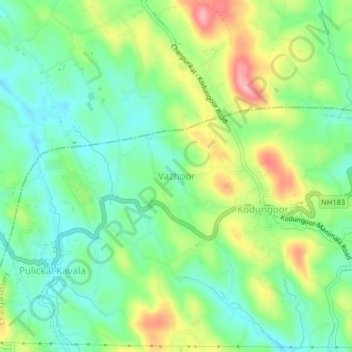
Name: Vazhoor topographic map, elevation, terrain.

Location: Vazhoor, Changanassery, Kottayam, Kerala, 686504, India (9.52320 76.65956 9.60320 76.73956)

Average elevation: 86 m

Minimum elevation: 27 m

Maximum elevation: 168 m

Other topographic maps

Click on a map to view its topography, its elevation and its terrain.

Cheeranchira

India > Kerala > Changanassery > Kurishummoodu

Average elevation: 18 m

Thrikkodithanam

India > Kerala > Changanassery > Valiyakulam

Average elevation: 22 m

Kurichy

India > Kerala > Changanassery > Putuppalli

Average elevation: 11 m

Mammoodu

India > Kerala > Changanassery > Mammood

Average elevation: 31 m

Erumathala

India > Kerala > Changanassery > Kangazha

Average elevation: 86 m

Gear up for your next adventure:

🚲Heavy Duty Bike Lock - Secure your bike at the trailhead or during stops
🔪Outdoor Multitool - Versatile tool for repairs and food prep in the wild
🕯️Camping Lantern - Illuminates your entire campsite with high-efficiency LEDs
🧢Outdoor Cap - Protective cap for sun and rain during hikes
🥾Trail Hiking Boots - Supportive boots for rough trails

As an Amazon Associate, this site earns from qualifying purchases at no extra cost to you.