
Sioux Lookout topographic map
Click on the map to display elevation.
About this map
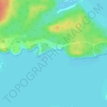
Name: Sioux Lookout topographic map, elevation, terrain.
Average elevation: 363 m
Minimum elevation: 353 m
Maximum elevation: 397 m
Kenora District trails, hiking, mountain biking, running and outdoor activities
Other topographic maps
Click on a map to view its topography, its elevation and its terrain.
Dogtooth Lake
Canada > Ontario > Kenora District > Unorganized Kenora District
Average elevation: 361 m
MacDowell Lake
Canada > Ontario > Kenora District > Unorganized Kenora District
Average elevation: 386 m
Big Canon Lake
Canada > Ontario > Kenora District > Unorganized Kenora District
Average elevation: 363 m
Minnitaki Lake
Canada > Ontario > Kenora District > Unorganized Kenora District
Average elevation: 386 m
lac Seul
Canada > Ontario > Kenora District > Unorganized Kenora District
Lac Seul is a large, crescent shaped reservoir in Kenora District, northwestern Ontario, Canada. It is approximately 241 km (150 mi) long. It has a maximum (regulated) depth of 47.2 m, with a surface elevation of 357 m above sea level. Its level is raised in the summer and then drawn down in the winter months…
Average elevation: 374 m
Sioux Narrows
Canada > Ontario > Kenora District > Sioux Narrows-Nestor Falls Township
Average elevation: 329 m
Lake Charles
Canada > Ontario > Kenora District > Unorganized Kenora District
Average elevation: 346 m
Northwest Angle 33 First Nation
Canada > Ontario > Kenora District > Whitefish Bay
Average elevation: 332 m
Fiddler Lake
Canada > Ontario > Kenora District > Unorganized Kenora District
Average elevation: 293 m
Nestor Falls
Canada > Ontario > Kenora District > Sioux Narrows-Nestor Falls Township
Average elevation: 337 m
Hudson Bay Lowlands
Canada > Ontario > Kenora District > Unorganized Kenora District
Average elevation: 17 m
Sioux Lookout
Canada > Ontario > Kenora District
Sioux Lookout is located approximately 350 kilometres (220 mi) northwest of Thunder Bay, at an elevation of 383 metres (1,257 ft), and it covers an area of 536 square kilometres (207 sq mi), of which 157 square kilometres (61 sq mi) is lake and wetlands.
Average elevation: 377 m
Maynard Lake
Canada > Ontario > Kenora District > Unorganized Kenora District
Average elevation: 337 m
Clearwater Bay
Canada > Ontario > Kenora District > Unorganized Kenora District
Average elevation: 334 m
Whitefish Lake
Canada > Ontario > Kenora District > Unorganized Kenora District
Average elevation: 380 m
Wabauskang 21
Canada > Ontario > Kenora District > Unorganized Kenora District
Average elevation: 368 m
Confederation Lake
Canada > Ontario > Kenora District > Unorganized Kenora District
Average elevation: 414 m
Fredart Lake
Canada > Ontario > Kenora District > Unorganized Kenora District
Average elevation: 409 m
Two Island Lake
Canada > Ontario > Kenora District > Unorganized Kenora District
Average elevation: 361 m
Affleck Lake
Canada > Ontario > Kenora District > Unorganized Kenora District
Average elevation: 421 m
Spadina Lake
Canada > Ontario > Kenora District > Unorganized Kenora District
Average elevation: 376 m
McIntosh Lake
Canada > Ontario > Kenora District > Unorganized Kenora District
Average elevation: 395 m
Gordon Island
Canada > Ontario > Kenora District > Unorganized Kenora District
Average elevation: 349 m
Blackstone Lake
Canada > Ontario > Kenora District > Unorganized Kenora District
Average elevation: 382 m
Winnipeg River
Canada > Ontario > Kenora District > Unorganized Kenora District
Average elevation: 317 m
Lac Seul
Canada > Ontario > Kenora District
Lac Seul is a large, crescent-shaped reservoir in Kenora District, northwestern Ontario, Canada. It is approximately 241 km (150 mi) long. It has a maximum (regulated) depth of 47.2 m, with a surface elevation of 357 m above sea level. Its level is raised in the summer and then drawn down in the winter months…
Average elevation: 388 m
Bertrand Lake
Canada > Ontario > Kenora District > Unorganized Kenora District
Average elevation: 414 m
Mackey Island
Canada > Ontario > Kenora District > Unorganized Kenora District
Average elevation: 336 m
Wabaskang Lake
Canada > Ontario > Kenora District > Unorganized Kenora District
Average elevation: 375 m
Minnitaki Lake
Canada > Ontario > Kenora District > Unorganized Kenora District
Average elevation: 386 m
Kukukus Lake
Canada > Ontario > Kenora District > Unorganized Kenora District
Average elevation: 405 m
Antenna Lake
Canada > Ontario > Kenora District > Unorganized Kenora District
Average elevation: 393 m
Berry Lake
Canada > Ontario > Kenora District > Sioux Narrows-Nestor Falls Township
Average elevation: 340 m
Cluster Lakes
Canada > Ontario > Kenora District > Unorganized Kenora District
Average elevation: 443 m
Cameron Island
Canada > Ontario > Kenora District > Unorganized Kenora District
Average elevation: 338 m
Nestor Falls
Canada > Ontario > Kenora District > Sioux Narrows-Nestor Falls Township
Average elevation: 337 m