
Clearwater Bay topographic map
Interactive map
Click on the map to display elevation.
About this map
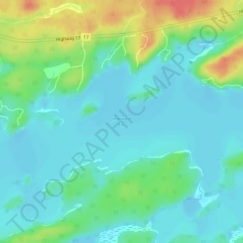
Name: Clearwater Bay topographic map, elevation, terrain.
Average elevation: 334 m
Minimum elevation: 318 m
Maximum elevation: 376 m
Other topographic maps
Click on a map to view its topography, its elevation and its terrain.
Lake Charles
Canada > Ontario > Kenora District > Unorganized Kenora District
Lake Charles, Unorganized Kenora District, Kenora District, Northwestern Ontario, Ontario, Canada
Average elevation: 346 m
Blackstone Lake
Canada > Ontario > Kenora District > Unorganized Kenora District
Blackstone Lake, Unorganized Kenora District, Kenora District, Northwestern Ontario, Ontario, Canada
Average elevation: 382 m
Laclu
Canada > Ontario > Kenora District > Unorganized Kenora District
Laclu, Unorganized Kenora District, Kenora District, Northwestern Ontario, Ontario, Canada
Average elevation: 327 m
Burditt Lake
Canada > Ontario > Kenora District > Unorganized Kenora District
Burditt Lake, Unorganized Kenora District, Kenora District, Northwestern Ontario, Ontario, Canada
Average elevation: 367 m
Ingolf
Canada > Ontario > Kenora District > Unorganized Kenora District
Ingolf, Unorganized Kenora District, Kenora District, Northwestern Ontario, Ontario, Canada
Average elevation: 363 m
MacDowell Lake
Canada > Ontario > Kenora District > Unorganized Kenora District
MacDowell Lake, Unorganized Kenora District, Kenora District, Northwestern Ontario, Ontario, Canada
Average elevation: 386 m
Rowdy Lake
Canada > Ontario > Kenora District > Unorganized Kenora District
Rowdy Lake, Unorganized Kenora District, Kenora District, Northwestern Ontario, Ontario, Canada
Average elevation: 370 m
Wolf Island
Canada > Ontario > Kenora District > Unorganized Kenora District
Wolf Island, Unorganized Kenora District, Kenora District, Northwestern Ontario, Ontario, Canada
Average elevation: 327 m
Gordon Island
Canada > Ontario > Kenora District > Unorganized Kenora District
Gordon Island, Unorganized Kenora District, Kenora District, Northwestern Ontario, Ontario, P9N 4J1, Canada
Average elevation: 349 m
McIntosh Lake
Canada > Ontario > Kenora District > Unorganized Kenora District
McIntosh Lake, Unorganized Kenora District, Kenora District, Northwestern Ontario, Ontario, Canada
Average elevation: 395 m
Oxdrift
Canada > Ontario > Kenora District > Unorganized Kenora District
Oxdrift, Unorganized Kenora District, Kenora District, Northwestern Ontario, Ontario, Canada
Average elevation: 364 m
Granite Lake
Canada > Ontario > Kenora District > Unorganized Kenora District
Granite Lake, Unorganized Kenora District, Kenora District, Northwestern Ontario, Ontario, Canada
Average elevation: 355 m
Hudson Bay Lowlands
Canada > Ontario > Kenora District > Unorganized Kenora District
Hudson Bay Lowlands, Unorganized Kenora District, Kenora District, Northwestern Ontario, Ontario, Canada
Average elevation: 17 m
Ena Lake
Canada > Ontario > Kenora District > Unorganized Kenora District
Ena Lake, Unorganized Kenora District, Kenora District, Northwestern Ontario, Ontario, Canada
Average elevation: 350 m
lac Seul
Canada > Ontario > Kenora District > Unorganized Kenora District
lac Seul, Unorganized Kenora District, Kenora District, Northwestern Ontario, Ontario, Canada
Average elevation: 374 m
Spadina Lake
Canada > Ontario > Kenora District > Unorganized Kenora District
Spadina Lake, Unorganized Kenora District, Kenora District, Northwestern Ontario, Ontario, Canada
Average elevation: 376 m
Affleck Lake
Canada > Ontario > Kenora District > Unorganized Kenora District
Affleck Lake, Unorganized Kenora District, Kenora District, Northwestern Ontario, Ontario, Canada
Average elevation: 421 m
Two Island Lake
Canada > Ontario > Kenora District > Unorganized Kenora District
Two Island Lake, Unorganized Kenora District, Kenora District, Northwestern Ontario, Ontario, Canada
Average elevation: 361 m
Confederation Lake
Canada > Ontario > Kenora District > Unorganized Kenora District
Confederation Lake, Unorganized Kenora District, Kenora District, Northwestern Ontario, Ontario, Canada
Average elevation: 414 m
Kushog Lake
Canada > Ontario > Kenora District > Unorganized Kenora District
Kushog Lake, Unorganized Kenora District, Kenora District, Northwestern Ontario, Ontario, Canada
Average elevation: 405 m
Fredart Lake
Canada > Ontario > Kenora District > Unorganized Kenora District
Fredart Lake, Unorganized Kenora District, Kenora District, Northwestern Ontario, Ontario, Canada
Average elevation: 409 m
Canyon Lake
Canada > Ontario > Kenora District > Unorganized Kenora District
Canyon Lake, Unorganized Kenora District, Kenora District, Northwestern Ontario, Ontario, Canada
Average elevation: 405 m
Axe Lake
Canada > Ontario > Kenora District > Unorganized Kenora District
Axe Lake, Unorganized Kenora District, Kenora District, Northwestern Ontario, Ontario, Canada
Average elevation: 369 m
Dogtooth Lake
Canada > Ontario > Kenora District > Unorganized Kenora District
Dogtooth Lake, Unorganized Kenora District, Kenora District, Northwestern Ontario, Ontario, Canada
Average elevation: 364 m
Dingwall Island
Canada > Ontario > Kenora District > Unorganized Kenora District
Dingwall Island, Unorganized Kenora District, Kenora District, Northwestern Ontario, Ontario, Canada
Average elevation: 325 m
Minnitaki Lake
Canada > Ontario > Kenora District > Unorganized Kenora District
Minnitaki Lake, Unorganized Kenora District, Kenora District, Northwestern Ontario, Ontario, Canada
Average elevation: 386 m
Minaki
Canada > Ontario > Kenora District > Unorganized Kenora District
Minaki, Unorganized Kenora District, Kenora District, Northwestern Ontario, Ontario, Canada
Average elevation: 325 m
Muskeg River
Canada > Ontario > Kenora District > Unorganized Kenora District
Muskeg River, Unorganized Kenora District, Kenora District, Northwestern Ontario, Ontario, Canada
Average elevation: 363 m
Whitefish Lake
Canada > Ontario > Kenora District > Unorganized Kenora District
Whitefish Lake, Unorganized Kenora District, Kenora District, Northwestern Ontario, Ontario, Canada
Average elevation: 380 m
Slate Falls
Canada > Ontario > Kenora District > Unorganized Kenora District
Slate Falls, Unorganized Kenora District, Kenora District, Northwestern Ontario, Ontario, Canada
Average elevation: 385 m
Boyne Lake
Canada > Ontario > Kenora District > Unorganized Kenora District
Boyne Lake, Unorganized Kenora District, Kenora District, Northwestern Ontario, Ontario, Canada
Average elevation: 361 m
Muskeg River
Canada > Ontario > Kenora District > Unorganized Kenora District
Muskeg River, Unorganized Kenora District, Kenora District, Northwestern Ontario, Ontario, Canada
Average elevation: 357 m
Stormy Lake
Canada > Ontario > Kenora District > Unorganized Kenora District
Stormy Lake, Unorganized Kenora District, Kenora District, Northwestern Ontario, Ontario, Canada
Average elevation: 414 m
Lac Seul
Canada > Ontario > Kenora District > Unorganized Kenora District
Lac Seul, Unorganized Kenora District, Kenora District, Northwestern Ontario, Ontario, Canada
Average elevation: 371 m
Carroll Lake
Canada > Ontario > Kenora District > Unorganized Kenora District
Carroll Lake, Unorganized Kenora District, Kenora District, Northwestern Ontario, Ontario, Canada
Average elevation: 338 m
Chisholm Island
Canada > Ontario > Kenora District > Unorganized Kenora District
Chisholm Island, Unorganized Kenora District, Kenora District, Northwestern Ontario, Ontario, Canada
Average elevation: 323 m
Maynard Lake
Canada > Ontario > Kenora District > Unorganized Kenora District
Maynard Lake, Unorganized Kenora District, Kenora District, Northwestern Ontario, Ontario, Canada
Average elevation: 337 m
Beauty Lake
Canada > Ontario > Kenora District > Unorganized Kenora District
Beauty Lake, Unorganized Kenora District, Kenora District, Northwestern Ontario, Ontario, Canada
Average elevation: 348 m
Mills Lake
Canada > Ontario > Kenora District > Unorganized Kenora District
Mills Lake, Unorganized Kenora District, Kenora District, Northwestern Ontario, Ontario, Canada
Average elevation: 380 m
Betula Lake
Canada > Ontario > Kenora District > Unorganized Kenora District
Betula Lake, Unorganized Kenora District, Kenora District, Northwestern Ontario, Ontario, Canada
Average elevation: 371 m
Artery Lake
Canada > Ontario > Kenora District > Unorganized Kenora District
Artery Lake, Unorganized Kenora District, Kenora District, Northwestern Ontario, Ontario, Canada
Average elevation: 334 m
Nine Mile Lake
Canada > Ontario > Kenora District > Unorganized Kenora District
Nine Mile Lake, Unorganized Kenora District, Kenora District, Northwestern Ontario, Ontario, Canada
Average elevation: 413 m
Arpin Lake
Canada > Ontario > Kenora District > Unorganized Kenora District
Arpin Lake, Unorganized Kenora District, Kenora District, Northwestern Ontario, Ontario, Canada
Average elevation: 383 m
Big Island Lake
Canada > Ontario > Kenora District > Unorganized Kenora District
Big Island Lake, Unorganized Kenora District, Kenora District, Northwestern Ontario, Ontario, Canada
Average elevation: 430 m
Mackey Island
Canada > Ontario > Kenora District > Unorganized Kenora District
Mackey Island, Unorganized Kenora District, Kenora District, Northwestern Ontario, Ontario, Canada
Average elevation: 336 m
Lansdowne House
Canada > Ontario > Kenora District > Unorganized Kenora District
Lansdowne House, Unorganized Kenora District, Kenora District, Northwestern Ontario, Ontario, Canada
Average elevation: 242 m
P.E.I.
Canada > Ontario > Kenora District > Unorganized Kenora District
P.E.I., Unorganized Kenora District, Kenora District, Northwestern Ontario, Ontario, Canada
Average elevation: 317 m
Lingman Lake
Canada > Ontario > Kenora District > Unorganized Kenora District
Lingman Lake, Unorganized Kenora District, Kenora District, Northwestern Ontario, Ontario, Canada
Average elevation: 262 m