
Oxdrift topographic map
Click on the map to display elevation.
About this map
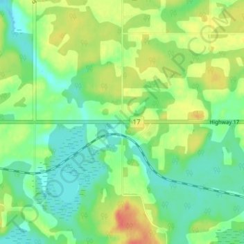
Name: Oxdrift topographic map, elevation, terrain.
Average elevation: 364 m
Minimum elevation: 347 m
Maximum elevation: 390 m
Kenora District trails, hiking, mountain biking, running and outdoor activities
Other topographic maps
Click on a map to view its topography, its elevation and its terrain.
Dogtooth Lake
Canada > Ontario > Kenora District > Unorganized Kenora District
Average elevation: 361 m
Minnitaki Lake
Canada > Ontario > Kenora District > Unorganized Kenora District
Average elevation: 386 m
lac Seul
Canada > Ontario > Kenora District > Unorganized Kenora District
Lac Seul is a large, crescent shaped reservoir in Kenora District, northwestern Ontario, Canada. It is approximately 241 km (150 mi) long. It has a maximum (regulated) depth of 47.2 m, with a surface elevation of 357 m above sea level. Its level is raised in the summer and then drawn down in the winter months…
Average elevation: 374 m
Granite Lake
Canada > Ontario > Kenora District > Unorganized Kenora District
Average elevation: 355 m
Burditt Lake
Canada > Ontario > Kenora District > Unorganized Kenora District
Average elevation: 367 m
MacDowell Lake
Canada > Ontario > Kenora District > Unorganized Kenora District
Average elevation: 386 m
Lake Charles
Canada > Ontario > Kenora District > Unorganized Kenora District
Average elevation: 346 m
Fiddler Lake
Canada > Ontario > Kenora District > Unorganized Kenora District
Average elevation: 293 m
Cardinal (Lac) Lake
Canada > Ontario > Kenora District > Unorganized Kenora District
Average elevation: 392 m
Big Canon Lake
Canada > Ontario > Kenora District > Unorganized Kenora District
Average elevation: 363 m
Big Island Lake
Canada > Ontario > Kenora District > Unorganized Kenora District
Average elevation: 430 m
Carroll Lake
Canada > Ontario > Kenora District > Unorganized Kenora District
Average elevation: 338 m
Maynard Lake
Canada > Ontario > Kenora District > Unorganized Kenora District
Average elevation: 337 m
Whitefish Lake
Canada > Ontario > Kenora District > Unorganized Kenora District
Average elevation: 380 m
Dingwall Island
Canada > Ontario > Kenora District > Unorganized Kenora District
Average elevation: 325 m
Confederation Lake
Canada > Ontario > Kenora District > Unorganized Kenora District
Average elevation: 414 m
Fredart Lake
Canada > Ontario > Kenora District > Unorganized Kenora District
Average elevation: 409 m
Two Island Lake
Canada > Ontario > Kenora District > Unorganized Kenora District
Average elevation: 361 m
Affleck Lake
Canada > Ontario > Kenora District > Unorganized Kenora District
Average elevation: 421 m
Spadina Lake
Canada > Ontario > Kenora District > Unorganized Kenora District
Average elevation: 376 m
McIntosh Lake
Canada > Ontario > Kenora District > Unorganized Kenora District
Average elevation: 395 m
Blackstone Lake
Canada > Ontario > Kenora District > Unorganized Kenora District
Average elevation: 382 m
Winnipeg River
Canada > Ontario > Kenora District > Unorganized Kenora District
Average elevation: 317 m
Grindstone Lake
Canada > Ontario > Kenora District > Unorganized Kenora District
Average elevation: 371 m
Warwick Lake
Canada > Ontario > Kenora District > Unorganized Kenora District
Average elevation: 341 m
Slate Islands
Canada > Ontario > Kenora District > Unorganized Kenora District
Average elevation: 322 m
Bertrand Lake
Canada > Ontario > Kenora District > Unorganized Kenora District
Average elevation: 414 m
Nine Mile Lake
Canada > Ontario > Kenora District > Unorganized Kenora District
Average elevation: 413 m
Chisholm Island
Canada > Ontario > Kenora District > Unorganized Kenora District
Average elevation: 323 m
Muskeg River
Canada > Ontario > Kenora District > Unorganized Kenora District
Average elevation: 357 m
Muskeg River
Canada > Ontario > Kenora District > Unorganized Kenora District
Average elevation: 363 m
Tablerock Lake
Canada > Ontario > Kenora District > Unorganized Kenora District
Average elevation: 384 m
Wabaskang Lake
Canada > Ontario > Kenora District > Unorganized Kenora District
Average elevation: 375 m
Minnitaki Lake
Canada > Ontario > Kenora District > Unorganized Kenora District
Average elevation: 386 m
Kukukus Lake
Canada > Ontario > Kenora District > Unorganized Kenora District
Average elevation: 405 m
Antenna Lake
Canada > Ontario > Kenora District > Unorganized Kenora District
Average elevation: 393 m
Cluster Lakes
Canada > Ontario > Kenora District > Unorganized Kenora District
Average elevation: 443 m
Little Boulder Lake
Canada > Ontario > Kenora District > Unorganized Kenora District
Average elevation: 359 m