
Make a donation
Gear up for your next adventure:
As an Amazon Associate, this site earns from qualifying purchases at no extra cost to you.
Saginaw County topographic map
Click on the map to display elevation.
Make a donation
Gear up for your next adventure:
As an Amazon Associate, this site earns from qualifying purchases at no extra cost to you.
Saginaw County
According to the U.S. Census Bureau, the county has a total area of 816 square miles (2,110 km2), of which 800 square miles (2,100 km2) is land and 16 square miles (41 km2) (1.9%) is water. It is part of the Flint/Tri-Cities region of Mid-Michigan. The median elevation in Saginaw County, Michigan is 620 feet (190 m) above sea level.
Make a donation
Gear up for your next adventure:
As an Amazon Associate, this site earns from qualifying purchases at no extra cost to you.
About this map
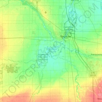
Name: Saginaw County topographic map, elevation, terrain.
Location: Saginaw County, Michigan, United States (43.12842 -84.36986 43.56890 -83.69520)
Average elevation: 193 m
Minimum elevation: 174 m
Maximum elevation: 243 m
Make a donation
Gear up for your next adventure:
As an Amazon Associate, this site earns from qualifying purchases at no extra cost to you.
Other topographic maps
Click on a map to view its topography, its elevation and its terrain.
Dean Lake
United States > Michigan > Kent County > Plainfield Charter Township
Average elevation: 228 m
Muskegon River - South Channel
United States > Michigan > Muskegon County > Muskegon
Average elevation: 188 m
Make a donation
Gear up for your next adventure:
As an Amazon Associate, this site earns from qualifying purchases at no extra cost to you.
Make a donation
Gear up for your next adventure:
As an Amazon Associate, this site earns from qualifying purchases at no extra cost to you.
Grand Island
United States > Michigan > Presque Isle County > Presque Isle Township
Average elevation: 182 m
Make a donation
Gear up for your next adventure:
As an Amazon Associate, this site earns from qualifying purchases at no extra cost to you.
Make a donation
Gear up for your next adventure:
As an Amazon Associate, this site earns from qualifying purchases at no extra cost to you.
Make a donation
Gear up for your next adventure:
As an Amazon Associate, this site earns from qualifying purchases at no extra cost to you.
Make a donation
Gear up for your next adventure:
As an Amazon Associate, this site earns from qualifying purchases at no extra cost to you.
Oakley Park
United States > Michigan > Oakland County > Commerce Charter Township
Average elevation: 282 m
Make a donation
Gear up for your next adventure:
As an Amazon Associate, this site earns from qualifying purchases at no extra cost to you.
Make a donation
Gear up for your next adventure:
As an Amazon Associate, this site earns from qualifying purchases at no extra cost to you.
Make a donation
Gear up for your next adventure:
As an Amazon Associate, this site earns from qualifying purchases at no extra cost to you.
Make a donation
Gear up for your next adventure:
As an Amazon Associate, this site earns from qualifying purchases at no extra cost to you.
North Branch Marsh Drain
United States > Michigan > Washtenaw County > Augusta Township
Average elevation: 206 m
Make a donation
Gear up for your next adventure:
As an Amazon Associate, this site earns from qualifying purchases at no extra cost to you.
Make a donation
Gear up for your next adventure:
As an Amazon Associate, this site earns from qualifying purchases at no extra cost to you.
South Gull Lake
United States > Michigan > Kalamazoo County > South Gull Lake
Average elevation: 274 m
Make a donation
Gear up for your next adventure:
As an Amazon Associate, this site earns from qualifying purchases at no extra cost to you.
Make a donation
Gear up for your next adventure:
As an Amazon Associate, this site earns from qualifying purchases at no extra cost to you.
Make a donation
Gear up for your next adventure:
As an Amazon Associate, this site earns from qualifying purchases at no extra cost to you.