
Make a donation
Gear up for your next adventure:
As an Amazon Associate, this site earns from qualifying purchases at no extra cost to you.
Reith bei Kitzbühel topographic map
Click on the map to display elevation.
Make a donation
Gear up for your next adventure:
As an Amazon Associate, this site earns from qualifying purchases at no extra cost to you.
Reith bei Kitzbühel
Reith bei Kitzbühel liegt etwa fünf Kilometer nordwestlich der Bezirkshauptstadt Kitzbühel, eingebettet zwischen Bichlach und dem Rauhen Kopf. Die Gemeinde gehört zum Leukental und bildet den Übergang in das Brixental. Der Ort wird von der Reither Ache durchflossen und liegt wie die Stadt Kitzbühel auf 762 m Seehöhe.
Make a donation
Gear up for your next adventure:
As an Amazon Associate, this site earns from qualifying purchases at no extra cost to you.
About this map
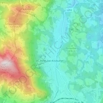
Name: Reith bei Kitzbühel topographic map, elevation, terrain.
Location: Reith bei Kitzbühel, Bezirk Kitzbühel, Tirol, Österreich (47.45561 12.30879 47.50524 12.37086)
Average elevation: 921 m
Minimum elevation: 695 m
Maximum elevation: 1,557 m
Make a donation
Gear up for your next adventure:
As an Amazon Associate, this site earns from qualifying purchases at no extra cost to you.
Other topographic maps
Click on a map to view its topography, its elevation and its terrain.
Scheffau
Österreich > Tirol > Bezirk Kitzbühel > Marktgemeinde St. Johann in Tirol
Average elevation: 939 m
Schafsiedel
Österreich > Tirol > Bezirk Kitzbühel > Hopfgarten im Brixental
Average elevation: 2,086 m
Make a donation
Gear up for your next adventure:
As an Amazon Associate, this site earns from qualifying purchases at no extra cost to you.
Außersalvenberg
Österreich > Tirol > Bezirk Kitzbühel > Westendorf > Feichten
Average elevation: 944 m
Make a donation
Gear up for your next adventure:
As an Amazon Associate, this site earns from qualifying purchases at no extra cost to you.
Schwaigerberg
Österreich > Tirol > Bezirk Kitzbühel > Westendorf > Unterwindau
Average elevation: 924 m
Make a donation
Gear up for your next adventure:
As an Amazon Associate, this site earns from qualifying purchases at no extra cost to you.
Hahnenkamm
Österreich > Tirol > Bezirk Kitzbühel > Kitzbühel
Über Kitzbühel erhebt sich der Hahnenkamm mit einer Höhe von 1712 m ü. A. Der eigentlich höchste Punkt am Hahnenkamm ist die Ehrenbachhöhe mit einer Höhe von 1802 m ü. A.
Average elevation: 1,444 m
Pillersee
Österreich > Tirol > Bezirk Kitzbühel > Sankt Ulrich am Pillersee > Brunnerau
Seine Entstehung verdankt der Pillersee einem Bergsturz vor etwa 15.000 Jahren, der den Abfluss in Höhe der Öfenschlucht unterbrach und so den Pillersee aufstaute.
Average elevation: 1,076 m
Make a donation
Gear up for your next adventure:
As an Amazon Associate, this site earns from qualifying purchases at no extra cost to you.
Reith bei Kitzbühel
Österreich > Tirol > Bezirk Kitzbühel > Gemeinde Reith bei Kitzbühel > Reith bei Kitzbühel
Average elevation: 914 m
Going
Österreich > Tirol > Bezirk Kitzbühel > Gemeinde Going am Wilden Kaiser > Going
Average elevation: 892 m
Make a donation
Gear up for your next adventure:
As an Amazon Associate, this site earns from qualifying purchases at no extra cost to you.
Markbachjoch
Österreich > Tirol > Bezirk Kitzbühel > Marktgemeinde Hopfgarten im Brixental
Average elevation: 1,178 m
Hahnenkamm
Österreich > Tirol > Bezirk Kitzbühel > Stadt Kitzbühel
Über Kitzbühel erhebt sich der Hahnenkamm mit einer Höhe von 1712 m ü. A. Der eigentlich höchste Punkt am Hahnenkamm ist die Ehrenbachhöhe mit einer Höhe von 1802 m ü. A.
Average elevation: 1,440 m
Weiberndorf
Österreich > Tirol > Bezirk Kitzbühel > Marktgemeinde St. Johann in Tirol > Weiberndorf
Average elevation: 788 m
Make a donation
Gear up for your next adventure:
As an Amazon Associate, this site earns from qualifying purchases at no extra cost to you.
Kelchsau
Österreich > Tirol > Bezirk Kitzbühel > Hopfgarten im Brixental > Kelchsau
Average elevation: 1,134 m
Steinplatte
Österreich > Tirol > Bezirk Kitzbühel > Waidring
Die Steinplatte liegt im Gemeindegebiet von Unken und Lofer im Saalachtal, Pinzgau und von Waidring im Bezirk Kitzbühel. Der Hauptgipfel (1869 m ü. A.) liegt am Westrand der Formation. Oberhalb des Strubtals erstreckt sich die etwa 1000 Höhenmeter hohe Sonnwand bis zum Grubhörndl (1747 m ü. A.) und die…
Average elevation: 1,432 m
Pillersee
Österreich > Tirol > Bezirk Kitzbühel > Sankt Ulrich am Pillersee > Brunnerau
Seine Entstehung verdankt der Pillersee einem Bergsturz vor etwa 15.000 Jahren, der den Abfluss in Höhe der Öfenschlucht unterbrach und so den Pillersee aufstaute.
Average elevation: 1,076 m
Make a donation
Gear up for your next adventure:
As an Amazon Associate, this site earns from qualifying purchases at no extra cost to you.
Make a donation
Gear up for your next adventure:
As an Amazon Associate, this site earns from qualifying purchases at no extra cost to you.
Buchensteinwand
Österreich > Tirol > Bezirk Kitzbühel > Sankt Ulrich am Pillersee
Average elevation: 1,109 m
Make a donation
Gear up for your next adventure:
As an Amazon Associate, this site earns from qualifying purchases at no extra cost to you.
Make a donation
Gear up for your next adventure:
As an Amazon Associate, this site earns from qualifying purchases at no extra cost to you.
Make a donation
Gear up for your next adventure:
As an Amazon Associate, this site earns from qualifying purchases at no extra cost to you.
Brixental
Österreich > Tirol > Bezirk Kitzbühel > Westendorf
Mit rund 24.000 Gästebetten, 1,68 Millionen Nächtigungen im Winter und 1,32 Millionen im Sommer (Stand 2018) stellt der Tourismus einen wichtigen Wirtschaftszweig dar. Die SkiWelt Wilder Kaiser – Brixental ist eines der größten Schigebiete Österreichs. Neben den zahlreichen Beherbergungsbetrieben und…
Average elevation: 998 m