
Make a donation
Gear up for your next adventure:
As an Amazon Associate, this site earns from qualifying purchases at no extra cost to you.
Brixental topographic map
Click on the map to display elevation.
Make a donation
Gear up for your next adventure:
As an Amazon Associate, this site earns from qualifying purchases at no extra cost to you.
Brixental
Mit rund 24.000 Gästebetten, 1,68 Millionen Nächtigungen im Winter und 1,32 Millionen im Sommer (Stand 2018) stellt der Tourismus einen wichtigen Wirtschaftszweig dar. Die SkiWelt Wilder Kaiser – Brixental ist eines der größten Schigebiete Österreichs. Neben den zahlreichen Beherbergungsbetrieben und tourismusnahen Dienstleistern gibt es auch viele Handwerks- und Gewerbebetriebe. Durch die guten Voraussetzungen am Talboden und die ausgedehnten Almflächen in den höheren Regionen spielt auch die Landwirtschaft eine wichtige Rolle.
Make a donation
Gear up for your next adventure:
As an Amazon Associate, this site earns from qualifying purchases at no extra cost to you.
About this map
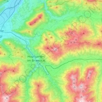
Name: Brixental topographic map, elevation, terrain.
Location: Brixental, Westendorf, Bezirk Kitzbühel, Tirol, Österreich (47.43227 12.07204 47.49262 12.31945)
Average elevation: 998 m
Minimum elevation: 484 m
Maximum elevation: 1,958 m
Make a donation
Gear up for your next adventure:
As an Amazon Associate, this site earns from qualifying purchases at no extra cost to you.
Other topographic maps
Click on a map to view its topography, its elevation and its terrain.
Außersalvenberg
Österreich > Tirol > Bezirk Kitzbühel > Westendorf > Feichten
Average elevation: 944 m
Make a donation
Gear up for your next adventure:
As an Amazon Associate, this site earns from qualifying purchases at no extra cost to you.
Schwaigerberg
Österreich > Tirol > Bezirk Kitzbühel > Westendorf > Unterwindau
Average elevation: 924 m
Make a donation
Gear up for your next adventure:
As an Amazon Associate, this site earns from qualifying purchases at no extra cost to you.