
Thank you for supporting this site ❤️
Make a donation
Make a donation
Gear up for your next adventure:
As an Amazon Associate, this site earns from qualifying purchases at no extra cost to you.
Riedlberg topographic map
Click on the map to display elevation.
Thank you for supporting this site ❤️
Make a donation
Make a donation
Gear up for your next adventure:
As an Amazon Associate, this site earns from qualifying purchases at no extra cost to you.
About this map
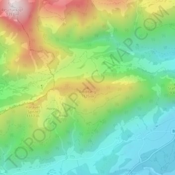
Name: Riedlberg topographic map, elevation, terrain.
Location: Riedlberg, Kössen, Bezirk Kitzbühel, Tirol, 6345, Österreich (47.66604 12.36280 47.66614 12.36290)
Average elevation: 881 m
Minimum elevation: 602 m
Maximum elevation: 1,364 m
Thank you for supporting this site ❤️
Make a donation
Make a donation
Gear up for your next adventure:
As an Amazon Associate, this site earns from qualifying purchases at no extra cost to you.