
Make a donation
Gear up for your next adventure:
As an Amazon Associate, this site earns from qualifying purchases at no extra cost to you.
Buchensteinwand topographic map
Click on the map to display elevation.
Make a donation
Gear up for your next adventure:
As an Amazon Associate, this site earns from qualifying purchases at no extra cost to you.
About this map
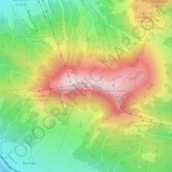
Name: Buchensteinwand topographic map, elevation, terrain.
Average elevation: 1,109 m
Minimum elevation: 826 m
Maximum elevation: 1,444 m
Make a donation
Gear up for your next adventure:
As an Amazon Associate, this site earns from qualifying purchases at no extra cost to you.
Other topographic maps
Click on a map to view its topography, its elevation and its terrain.
Pillersee
Österreich > Tirol > Bezirk Kitzbühel > Sankt Ulrich am Pillersee > Brunnerau
Seine Entstehung verdankt der Pillersee einem Bergsturz vor etwa 15.000 Jahren, der den Abfluss in Höhe der Öfenschlucht unterbrach und so den Pillersee aufstaute.
Average elevation: 1,076 m
Pillersee
Österreich > Tirol > Bezirk Kitzbühel > Sankt Ulrich am Pillersee > Brunnerau
Seine Entstehung verdankt der Pillersee einem Bergsturz vor etwa 15.000 Jahren, der den Abfluss in Höhe der Öfenschlucht unterbrach und so den Pillersee aufstaute.
Average elevation: 1,076 m