Geolocate

Villa Ridge topographic map

Click on the map to display elevation.

About this map

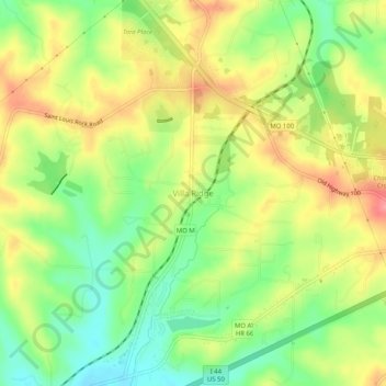
Name: Villa Ridge topographic map, elevation, terrain.

Location: Villa Ridge, Franklin County, Missouri, 63089, United States (38.45255 -90.90680 38.49255 -90.86680)

Average elevation: 198 m

Minimum elevation: 154 m

Maximum elevation: 245 m

Other topographic maps

Click on a map to view its topography, its elevation and its terrain.

Union

United States > Missouri > Franklin County

Average elevation: 190 m

Pacific

United States > Missouri > Franklin County

Average elevation: 173 m

Gerald

United States > Missouri > Franklin County

Average elevation: 266 m

Pacific

United States > Missouri > Franklin County

Average elevation: 173 m

Berger

United States > Missouri > Franklin County

Average elevation: 171 m

Berger

United States > Missouri > Franklin County

Average elevation: 171 m

Gear up for your next adventure:

🧥Insulated Jacket - Keep warm in cold outdoor conditions
Camping Essentials - All-in-one gear for a comfortable camping trip
🏃Hydration Running Vest - Carry water and maps close to your body for speed
Camping Groundsheet - Protect your tent from moisture and dirt
🥾Mountain Hiking Boots - High-traction boots for rocky terrain

As an Amazon Associate, this site earns from qualifying purchases at no extra cost to you.