Geolocate

Berger topographic map

Click on the map to display elevation.

👉 Easily get elevation data in JSON, GeoTIFF and KML formats using Elevation API
Thank you for supporting this site ❤️
Make a donation

About this map

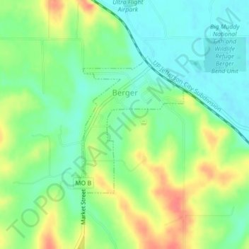
Name: Berger topographic map, elevation, terrain.

Location: Berger, Franklin County, Missouri, United States (38.66330 -91.34460 38.67813 -91.33062)

Average elevation: 171 m

Minimum elevation: 148 m

Maximum elevation: 207 m

Other topographic maps

Click on a map to view its topography, its elevation and its terrain.

Labadie

United States > Missouri > Franklin County

Average elevation: 168 m

Robertsville

United States > Missouri > Franklin County

Average elevation: 163 m

Luebbering

United States > Missouri > Franklin County

Average elevation: 219 m

Lonedell

United States > Missouri > Franklin County

Average elevation: 197 m

Saint Albans

United States > Missouri > Franklin County

Average elevation: 165 m

Villa Ridge

United States > Missouri > Franklin County

Average elevation: 198 m

Twin Springs

United States > Missouri > Franklin County

Average elevation: 213 m

Monday

United States > Missouri > Franklin County

Average elevation: 245 m

Gear up for your next adventure:

🧴Waterproofing Spray - Restore the DWR coating on jackets and tents
🧭GPS Handheld Device - Reliable GPS navigation for outdoor adventures
👟Leg Gaiters - Keep debris, mud, and snow out of your boots
🧥Waterproof Jacket - Lightweight rain jackets for hiking and outdoor activities
🥾Trail Running Shoes - Lightweight and durable shoes for trail running

As an Amazon Associate, this site earns from qualifying purchases at no extra cost to you.