Geolocate

Gerald topographic map

Click on the map to display elevation.

About this map

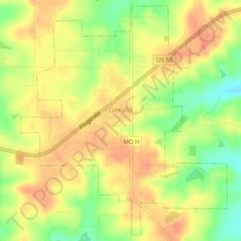
Name: Gerald topographic map, elevation, terrain.

Location: Gerald, Franklin County, Missouri, 66037, United States (38.38565 -91.34503 38.41139 -91.31546)

Average elevation: 266 m

Minimum elevation: 238 m

Maximum elevation: 283 m

Other topographic maps

Click on a map to view its topography, its elevation and its terrain.

Villa Ridge

United States > Missouri > Franklin County

Average elevation: 198 m

Labadie

United States > Missouri > Franklin County

Average elevation: 168 m

Robertsville

United States > Missouri > Franklin County

Average elevation: 163 m

Luebbering

United States > Missouri > Franklin County

Average elevation: 219 m

Lonedell

United States > Missouri > Franklin County

Average elevation: 197 m

Twin Springs

United States > Missouri > Franklin County

Average elevation: 213 m

Saint Albans

United States > Missouri > Franklin County

Average elevation: 165 m

Monday

United States > Missouri > Franklin County

Average elevation: 245 m

Gear up for your next adventure:

🔋Emergency Crank Radio - Weather alerts and power without needing batteries
👟Sport Hiking Sandals - Breathable footwear for water crossings and camp rest
🛏️Sleeping Bag - Warm and compact sleeping bags for outdoor camping
🎒Backpack Rain Cover - External shield to keep your entire pack dry
🔥Emergency Fire Starter - Reliable ignition source for all weather conditions

As an Amazon Associate, this site earns from qualifying purchases at no extra cost to you.