Geolocate

Gainesville topographic map

Click on the map to display elevation.

About this map

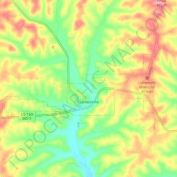
Name: Gainesville topographic map, elevation, terrain.

Location: Gainesville, Ozark County, Missouri, 65655, United States (36.59274 -92.47579 36.62338 -92.39320)

Average elevation: 280 m

Minimum elevation: 214 m

Maximum elevation: 355 m

Other topographic maps

Click on a map to view its topography, its elevation and its terrain.

Wasola

United States > Missouri > Ozark County

Average elevation: 361 m

Tecumseh

United States > Missouri > Ozark County

Average elevation: 220 m

Isabella

United States > Missouri > Ozark County

Average elevation: 266 m

Hardenville

United States > Missouri > Ozark County

Average elevation: 261 m

Dawt

United States > Missouri > Ozark County

Average elevation: 219 m

Gear up for your next adventure:

🥾Waterproof Hiking Boots - Boots keeping your feet dry in wet conditions
🧊Insulated Water Bottle - Keeps drinks cold in summer and prevents freezing in winter
🔭Compact Monocular - One-handed bird watching and trail spotting
🧥Waterproof Hiking Jacket - Protect yourself from rain and wind while hiking
🪑Insulated Seat Pad - Protect your seat from cold rocks and wet logs

As an Amazon Associate, this site earns from qualifying purchases at no extra cost to you.