Geolocate

Wasola topographic map

Click on the map to display elevation.

About this map

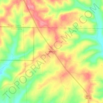
Name: Wasola topographic map, elevation, terrain.

Location: Wasola, Ozark County, Missouri, 65773, United States (36.77367 -92.59572 36.81367 -92.55572)

Average elevation: 361 m

Minimum elevation: 307 m

Maximum elevation: 406 m

Other topographic maps

Click on a map to view its topography, its elevation and its terrain.

Theodosia

United States > Missouri > Ozark County

Average elevation: 249 m

Bakersfield

United States > Missouri > Ozark County

Average elevation: 244 m

Gainesville

United States > Missouri > Ozark County

Average elevation: 280 m

Gear up for your next adventure:

🥤Collapsible Travel Cup - Saves space and weight in your mess kit
👖Convertible Hiking Pants - Zip-off legs to adapt to changing weather conditions
Camping Coffee Maker - Brew fresh coffee anywhere on the topographic map
🏕️Camping Hammock - Integrated protection for sleeping between trees
🧥Thermal Layer - Insulating layer for cold outdoor conditions

As an Amazon Associate, this site earns from qualifying purchases at no extra cost to you.