Geolocate

Hardenville topographic map

Click on the map to display elevation.

About this map

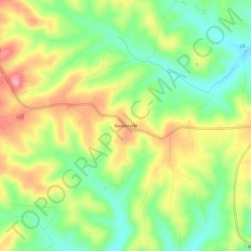
Name: Hardenville topographic map, elevation, terrain.

Location: Hardenville, Ozark County, Missouri, 65666, United States (36.56923 -92.39127 36.60923 -92.35127)

Average elevation: 261 m

Minimum elevation: 208 m

Maximum elevation: 324 m

Other topographic maps

Click on a map to view its topography, its elevation and its terrain.

Gainesville

United States > Missouri > Ozark County

Average elevation: 280 m

Theodosia

United States > Missouri > Ozark County

Average elevation: 249 m

Bakersfield

United States > Missouri > Ozark County

Average elevation: 244 m

Gear up for your next adventure:

🧦Hiking Liner Socks - Thin base layer to prevent friction and blisters
💧Hydration Bladder - Hands-free hydration solution for long treks
🥾Waterproof Trail Shoes - Shoes designed to handle wet terrain
🛶Waterproof Dry Bags - Keep electronics and clothes dry during river crossings
💡Portable Camping Lamp - Rechargeable lamp for campsite lighting

As an Amazon Associate, this site earns from qualifying purchases at no extra cost to you.