Geolocate

Isabella topographic map

Click on the map to display elevation.

About this map

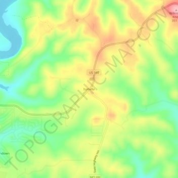
Name: Isabella topographic map, elevation, terrain.

Location: Isabella, Ozark County, Missouri, 65676, United States (36.56090 -92.63267 36.60090 -92.59267)

Average elevation: 266 m

Minimum elevation: 199 m

Maximum elevation: 346 m

Other topographic maps

Click on a map to view its topography, its elevation and its terrain.

Theodosia

United States > Missouri > Ozark County

Average elevation: 249 m

Gainesville

United States > Missouri > Ozark County

Average elevation: 280 m

Bakersfield

United States > Missouri > Ozark County

Average elevation: 244 m

Gear up for your next adventure:

🛌Down Sleeping Bag - Superior warmth-to-weight ratio for cold nights
🧦Hiking Socks - Moisture-wicking and comfortable socks for long hikes
🥾Durable Hiking Shoes - Long-lasting shoes for frequent hiking
🚲Heavy Duty Bike Lock - Secure your bike at the trailhead or during stops
🧢Hiking Sun Hat - Wide-brimmed protection for exposed mountain ridges

As an Amazon Associate, this site earns from qualifying purchases at no extra cost to you.