
Biringbulu topographic map
Click on the map to display elevation.
About this map
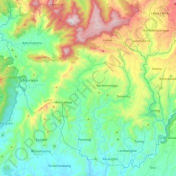
Name: Biringbulu topographic map, elevation, terrain.
Location: Biringbulu, Gowa, South Sulawesi, Sulawesi, Indonesia (-5.56968 119.62402 -5.39640 119.81621)
Average elevation: 380 m
Minimum elevation: 34 m
Maximum elevation: 1,129 m
Other topographic maps
Click on a map to view its topography, its elevation and its terrain.