Geolocate

Cresskill topographic map

Click on the map to display elevation.

About this map

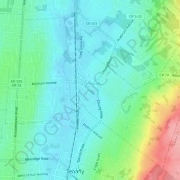
Name: Cresskill topographic map, elevation, terrain.

Location: Cresskill, Bergen County, New Jersey, 07626, United States (40.92590 -73.97987 40.95461 -73.93620)

Average elevation: 42 m

Minimum elevation: 9 m

Maximum elevation: 139 m

Other topographic maps

Click on a map to view its topography, its elevation and its terrain.

Darlington

United States > New Jersey > Bergen County > Mahwah

Average elevation: 129 m

Drag Hill

United States > New Jersey > Bergen County > Mahwah

Average elevation: 252 m

Stag Hill

United States > New Jersey > Bergen County > Mahwah

Average elevation: 204 m

Green Hill

United States > New Jersey > Bergen County > Mahwah

Average elevation: 175 m

Fardale

United States > New Jersey > Bergen County > Mahwah

Average elevation: 124 m

Cragmere

United States > New Jersey > Bergen County > Mahwah

Average elevation: 136 m

Teterboro

United States > New Jersey > Bergen County > Teterboro

Average elevation: 12 m

Westwood

United States > New Jersey > Bergen County > Westwood > Westwood

Average elevation: 31 m

Gear up for your next adventure:

🧶550 Survival Paracord - Versatile utility cord for emergency repairs and rigging
🧥Fleece Jacket - Warm and lightweight jacket for layering
🧥Waterproof Pants - Keep dry during rainy hiking conditions
🔦LED Flashlight - Powerful and long-lasting flashlight for camping and emergencies
🦯Trekking Poles - Reduced impact on joints for steep topographic climbs

As an Amazon Associate, this site earns from qualifying purchases at no extra cost to you.